Chapimarca geodata
Chapimarca (Apurímac) is a seat of a third-order administrative division; located in Peru in America/Lima (GMT-5) time zone. In our database, there are 305 cities with bigger population. Compared to other cities in Peru, 73.6% of cities are located further ↑North; 73.4% of cities are located further ←West and 73.7% of cities have lower elevation than Chapimarca. Note1


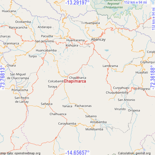
Chapimarca GPS coordinates[2]
13° 58' 31.008" South, 73° 3' 54" West
| Map corner | latitude | longitude |
|---|---|---|
| Upper-left | -13.29197°, | -73.76813° |
| Center: | -13.97528°, | -73.065° |
| Lower-right: | -14.65657°, | -72.36188° |
| Map W x H: | 151.7×151.7 km | = 94.3×94.3mi |
| max Lat: | -0.96667° ⇑73.6% North |
| Chapimarca: | -13.97528° |
| min Lat: | ⇓26.4% South -18.01465° |
| min Long | Chapimarca | max Long |
| -81.30472° | -73.065° | -69.04167° |
| W 73.4%⇐ | ⇒26.6% E |
Elevation
Elevation of Chapimarca is 3406 m = 11175 ft, and this is 1087.3 m = 3567 ft above average elevation for this country.
| Max E: |
5022 m = 16476 ft | 26.3% |
| Chapimarca | 3406 m 11175 ft | |
| Avg. | 2318.7 m = 7607 ft | |
Min E: |
1 m = 3 ft | 73.7% |
See also: Peru elevation on elevation.city.
Geographical zone
Chapimarca is located in South Torrid zone (between Equator and Tropic of Capricorn). Distance of this Southern Tropic circle is 1052 km =653.7 mi to South.| Distance of | km | miles | from Chapimarca |
|---|---|---|---|
| Equator | 1553.9 | 965.5 | to North |
| Tropic Capricorn | 1052 | 653.7 | to South |
| Antarctic Circle | 5847.3 | 3633.3 | to South |
| South Pole | 8453.2 | 5252.6 | to South |


Nearby cities:
15 places around Chapimarca: (largest is in red/bold)
• Ayahuay
25.9 km =16.1 mi,  180°
180°
• Capaya
31.7 km =19.7 mi,  239°
239°
• Circa
23.6 km =14.7 mi,  61°
61°
• Colcabamba
20 km =12.4 mi,  259°
259°
• Huayllo
28.1 km =17.5 mi,  231°
231°
• Kishuara
31.7 km =19.7 mi,  349°
349°
• Lucre
17.6 km =10.9 mi,  279°
279°
• Pachaconas
27.8 km =17.3 mi,  171°
171°
• Pichirhua
12.8 km =8 mi,  355°
355°
• Pocohuanca
26.9 km =16.7 mi, 184°
• Soraya
33.9 km =21.1 mi, 232°
• Tapairihua
20.2 km =12.6 mi,  204°
204°
• Tintay
13.2 km =8.2 mi, 277°
• Toraya
26.4 km =16.4 mi,  251°
251°
• Yanaca
28.2 km =17.5 mi, 196°
Sources, notices
• [Note1] Compared only with cities in Peru existing in our database
• [Src1] Map data: © OpenStreetMap contributors (CC-BY-SA)
• [Src2] Other city data from geonames.org with taken over terms of usage.
• [Src3] Geographical zone / Annual Mean Temperature by Robert A. Rohde @ Wikipedia
