Huancavelica geodata
Huancavelica is a seat of a first-order administrative division; located in Peru in America/Lima (GMT-5) time zone. With population of 41,576 people, there are 45 cities with bigger population in this country. Compared to other cities in Peru, 59.1% of cities are located further ↑North; 59% of cities are located further ←West and 86.5% of cities have lower elevation than Huancavelica. Note1
Administrative division(s):
- Level 1: Huancavelica
- Level 2: Provincia de Huancavelica
- Level 3: Ascension


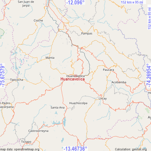
Huancavelica GPS coordinates[2]
12° 46' 57.396" South, 74° 58' 21.576" West
| Map corner | latitude | longitude |
|---|---|---|
| Upper-left | -12.096°, | -75.67579° |
| Center: | -12.78261°, | -74.97266° |
| Lower-right: | -13.46736°, | -74.26954° |
| Map W x H: | 152.5×152.5 km | = 94.8×94.8mi |
| max Lat: | -0.96667° ⇑59.1% North |
| Huancavelica: | -12.78261° |
| min Lat: | ⇓40.9% South -18.01465° |
| min Long | Huancavelica | max Long |
| -81.30472° | -74.97266° | -69.04167° |
| W 59%⇐ | ⇒41% E |
Elevation
Elevation of Huancavelica is 3704 m = 12152 ft, and this is 1385.3 m = 4545 ft above average elevation for this country.
| Max E: |
5022 m = 16476 ft | 13.5% |
| Huancavelica | 3704 m 12152 ft | |
| Avg. | 2318.7 m = 7607 ft | |
Min E: |
1 m = 3 ft | 86.5% |
See also: Huancavelica elevation on elevation.city.
Geographical zone
Huancavelica is located in South Torrid zone (between Equator and Tropic of Capricorn). Distance of this Southern Tropic circle is 1184.6 km =736.1 mi to South.| Distance of | km | miles | from Huancavelica |
|---|---|---|---|
| Equator | 1421.3 | 883.2 | to North |
| Tropic Capricorn | 1184.6 | 736.1 | to South |
| Antarctic Circle | 5979.9 | 3715.7 | to South |
| South Pole | 8585.8 | 5335 | to South |


Nearby cities:
15 places around Huancavelica: (largest is in red/bold)
• Acobamba
45 km =28 mi,  101°
101°
• Acobambilla
46.9 km =29.1 mi,  288°
288°
• Acoria
20.8 km =12.9 mi,  27°
27°
• Anchonga
31.6 km =19.6 mi,  110°
110°
• Callanmarca
38 km =23.6 mi, 104°
• Cuenca
39.4 km =24.5 mi,  350°
350°
• Huachocolpa
27.4 km =17 mi,  173°
173°
• Huayllahuara
47.5 km =29.5 mi,  333°
333°
• Izcuchaca
33.6 km =20.9 mi, 351°
• La Esmeralda
43.7 km =27.2 mi,  67°
67°
• Lircay
36.8 km =22.9 mi,  131°
131°
• Pampas
44.6 km =27.7 mi,  14°
14°
• Pilchaca
44.7 km =27.8 mi,  342°
342°
• Santa Ana
34.5 km =21.4 mi,  210°
210°
• Vilca
40.4 km =25.1 mi, 325°
Sources, notices
• [Note1] Compared only with cities in Peru existing in our database
• [Src1] Map data: © OpenStreetMap contributors (CC-BY-SA)
• [Src2] Other city data from geonames.org with taken over terms of usage.
• [Src3] Geographical zone / Annual Mean Temperature by Robert A. Rohde @ Wikipedia
