Cuenca geodata
Cuenca (Huancavelica) is a seat of a third-order administrative division; located in Peru in America/Lima (GMT-5) time zone. In our database, there are 305 cities with bigger population. Compared to other cities in Peru, 57% of cities are located further ↑North; 58.5% of cities are located further ←West and 56.5% of cities have lower elevation than Cuenca. Note1
Administrative division(s):
- Level 1: Huancavelica
- Level 2: Provincia de Huancavelica
- Level 3: Cuenca


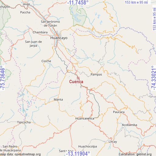
Cuenca GPS coordinates[2]
12° 25' 59.988" South, 75° 1' 59.988" West
| Map corner | latitude | longitude |
|---|---|---|
| Upper-left | -11.7458°, | -75.73646° |
| Center: | -12.43333°, | -75.03333° |
| Lower-right: | -13.11904°, | -74.33021° |
| Map W x H: | 152.7×152.7 km | = 94.9×94.9mi |
| max Lat: | -0.96667° ⇑57% North |
| Cuenca: | -12.43333° |
| min Lat: | ⇓43% South -18.01465° |
| min Long | Cuenca | max Long |
| -81.30472° | -75.03333° | -69.04167° |
| W 58.5%⇐ | ⇒41.5% E |
Elevation
Elevation of Cuenca is 3060 m = 10039 ft, and this is 741.3 m = 2432 ft above average elevation for this country.
| Max E: |
5022 m = 16476 ft | 43.5% |
| Cuenca | 3060 m 10039 ft | |
| Avg. | 2318.7 m = 7607 ft | |
Min E: |
1 m = 3 ft | 56.5% |
See also: Peru elevation on elevation.city.
Geographical zone
Cuenca is located in South Torrid zone (between Equator and Tropic of Capricorn). Distance of this Southern Tropic circle is 1223.5 km =760.2 mi to South.| Distance of | km | miles | from Cuenca |
|---|---|---|---|
| Equator | 1382.5 | 859 | to North |
| Tropic Capricorn | 1223.5 | 760.2 | to South |
| Antarctic Circle | 6018.7 | 3739.8 | to South |
| South Pole | 8624.6 | 5359.1 | to South |


Nearby cities:
15 places around Cuenca: (largest is in red/bold)
• Acoria
26.1 km =16.2 mi,  141°
141°
• Chacapampa
25.3 km =15.7 mi,  291°
291°
• Chicche
30.9 km =19.2 mi,  298°
298°
• Colca
24.8 km =15.4 mi,  306°
306°
• Colcabamba
36.4 km =22.6 mi,  84°
84°
• Cullhuas
26.5 km =16.5 mi,  326°
326°
• Huacrapuquio
34.2 km =21.3 mi,  324°
324°
• Huaribamba
20.6 km =12.8 mi,  26°
26°
• Huayllahuara
14.9 km =9.3 mi,  284°
284°
• Izcuchaca
5.8 km =3.6 mi,  161°
161°
• Pampas
18.6 km =11.6 mi, 76°
• Pazos
19.9 km =12.4 mi,  338°
338°
• Pilchaca
8.1 km =5 mi, 297°
• Sapallanga
35.5 km =22.1 mi, 332°
• Vilca
17.2 km =10.7 mi,  251°
251°
Sources, notices
• [Note1] Compared only with cities in Peru existing in our database
• [Src1] Map data: © OpenStreetMap contributors (CC-BY-SA)
• [Src2] Other city data from geonames.org with taken over terms of usage.
• [Src3] Geographical zone / Annual Mean Temperature by Robert A. Rohde @ Wikipedia
