Chupa geodata
Chupa (Puno) is a seat of a third-order administrative division; located in Peru in America/Lima (GMT-5) time zone. In our database, there are 305 cities with bigger population. Compared to other cities in Peru, 85.9% of cities are located further ↑North; 96.5% of cities are located further ←West and 91.5% of cities have lower elevation than Chupa. Note1


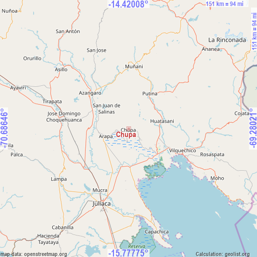
Chupa GPS coordinates[2]
15° 6' 0" South, 69° 58' 59.988" West
| Map corner | latitude | longitude |
|---|---|---|
| Upper-left | -14.42008°, | -70.68646° |
| Center: | -15.1°, | -69.98333° |
| Lower-right: | -15.77775°, | -69.28021° |
| Map W x H: | 151×151 km | = 93.8×93.8mi |
| max Lat: | -0.96667° ⇑85.9% North |
| Chupa: | -15.1° |
| min Lat: | ⇓14.1% South -18.01465° |
| min Long | Chupa | max Long |
| -81.30472° | -69.98333° | -69.04167° |
| W 96.5%⇐ | ⇒3.5% E |
Elevation
Elevation of Chupa is 3894 m = 12776 ft, and this is 1575.3 m = 5168 ft above average elevation for this country.
| Max E: |
5022 m = 16476 ft | 8.5% |
| Chupa | 3894 m 12776 ft | |
| Avg. | 2318.7 m = 7607 ft | |
Min E: |
1 m = 3 ft | 91.5% |
See also: Peru elevation on elevation.city.
Geographical zone
Chupa is located in South Torrid zone (between Equator and Tropic of Capricorn). Distance of this Southern Tropic circle is 927 km =576 mi to South.| Distance of | km | miles | from Chupa |
|---|---|---|---|
| Equator | 1679 | 1043.3 | to North |
| Tropic Capricorn | 927 | 576 | to South |
| Antarctic Circle | 5722.2 | 3555.6 | to South |
| South Pole | 8328.1 | 5174.8 | to South |


Nearby cities:
15 places around Chupa: (largest is in red/bold)
• Achaya
25.8 km =16 mi,  223°
223°
• Arapa
14.8 km =9.2 mi,  255°
255°
• Ayrampuni
12.1 km =7.5 mi,  62°
62°
• Azángaro
31.2 km =19.4 mi,  312°
312°
• Calapuja
34.7 km =21.6 mi,  226°
226°
• Caminaca
25.7 km =16 mi,  200°
200°
• Inchupalla
34.1 km =21.2 mi,  70°
70°
• Juliaca
47.3 km =29.4 mi, 199°
• Muñani
37.2 km =23.1 mi,  5°
5°
• Nicasio
32.2 km =20 mi,  242°
242°
• Pusi
37.4 km =23.2 mi,  171°
171°
• Putina
23.9 km =14.9 mi,  31°
31°
• Taraco
22.3 km =13.9 mi,  175°
175°
• Tirapata
47.8 km =29.7 mi,  290°
290°
• Vilque Chico
34.7 km =21.6 mi,  111°
111°
Sources, notices
• [Note1] Compared only with cities in Peru existing in our database
• [Src1] Map data: © OpenStreetMap contributors (CC-BY-SA)
• [Src2] Other city data from geonames.org with taken over terms of usage.
• [Src3] Geographical zone / Annual Mean Temperature by Robert A. Rohde @ Wikipedia
