Calapuja geodata
Calapuja (Puno) is a seat of a third-order administrative division; located in Peru in America/Lima (GMT-5) time zone. In our database, there are 305 cities with bigger population. Compared to other cities in Peru, 88.4% of cities are located further ↑North; 94.5% of cities are located further ←West and 89.9% of cities have lower elevation than Calapuja. Note1


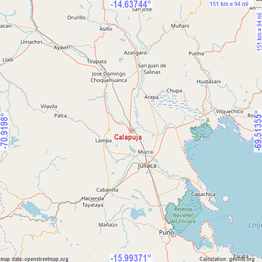
Calapuja GPS coordinates[2]
15° 19' 0.012" South, 70° 13' 0.012" West
| Map corner | latitude | longitude |
|---|---|---|
| Upper-left | -14.63744°, | -70.9198° |
| Center: | -15.31667°, | -70.21667° |
| Lower-right: | -15.99371°, | -69.51355° |
| Map W x H: | 150.8×150.8 km | = 93.7×93.7mi |
| max Lat: | -0.96667° ⇑88.4% North |
| Calapuja: | -15.31667° |
| min Lat: | ⇓11.6% South -18.01465° |
| min Long | Calapuja | max Long |
| -81.30472° | -70.21667° | -69.04167° |
| W 94.5%⇐ | ⇒5.5% E |
Elevation
Elevation of Calapuja is 3842 m = 12605 ft, and this is 1523.3 m = 4998 ft above average elevation for this country.
| Max E: |
5022 m = 16476 ft | 10.1% |
| Calapuja | 3842 m 12605 ft | |
| Avg. | 2318.7 m = 7607 ft | |
Min E: |
1 m = 3 ft | 89.9% |
See also: Peru elevation on elevation.city.
Geographical zone
Calapuja is located in South Torrid zone (between Equator and Tropic of Capricorn). Distance of this Southern Tropic circle is 902.9 km =561 mi to South.| Distance of | km | miles | from Calapuja |
|---|---|---|---|
| Equator | 1703.1 | 1058.3 | to North |
| Tropic Capricorn | 902.9 | 561 | to South |
| Antarctic Circle | 5698.1 | 3540.6 | to South |
| South Pole | 8304 | 5159.9 | to South |


Nearby cities:
15 places around Calapuja: (largest is in red/bold)
• Achaya
9.1 km =5.7 mi,  52°
52°
• Arapa
23 km =14.3 mi,  27°
27°
• Atuncolla
41.4 km =25.7 mi,  170°
170°
• Cabana
38.6 km =24 mi,  196°
196°
• Cabanilla
36.3 km =22.6 mi, 203°
• Caminaca
16.1 km =10 mi,  90°
90°
• Caracoto
30.5 km =19 mi,  155°
155°
• Chupa
34.7 km =21.6 mi, 46°
• Coata
39.9 km =24.8 mi,  134°
134°
• Juliaca
22.3 km =13.9 mi, 156°
• Lampa
16.5 km =10.3 mi,  257°
257°
• Nicasio
9.9 km =6.2 mi,  338°
338°
• Palca
41.9 km =26 mi,  282°
282°
• Pusi
33 km =20.5 mi,  113°
113°
• Taraco
26.9 km =16.7 mi, 86°
Sources, notices
• [Note1] Compared only with cities in Peru existing in our database
• [Src1] Map data: © OpenStreetMap contributors (CC-BY-SA)
• [Src2] Other city data from geonames.org with taken over terms of usage.
• [Src3] Geographical zone / Annual Mean Temperature by Robert A. Rohde @ Wikipedia
