Azángaro geodata
Azángaro (Puno) is a populated place; located in Peru in America/Lima (GMT-5) time zone. With population of 13,290 people, there are 125 cities with bigger population in this country. Compared to other cities in Peru, 84.9% of cities are located further ↑North; 94.8% of cities are located further ←West and 90.9% of cities have lower elevation than Azángaro. Note1


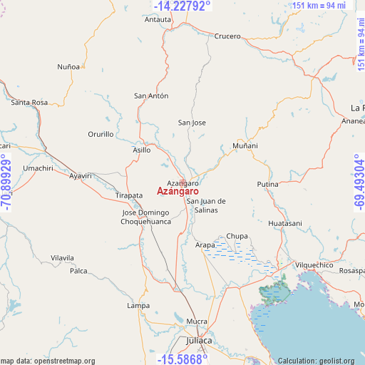
Azángaro GPS coordinates[2]
14° 54' 30.348" South, 70° 11' 46.176" West
| Map corner | latitude | longitude |
|---|---|---|
| Upper-left | -14.22792°, | -70.89929° |
| Center: | -14.90843°, | -70.19616° |
| Lower-right: | -15.5868°, | -69.49304° |
| Map W x H: | 151.1×151.1 km | = 93.9×93.9mi |
| max Lat: | -0.96667° ⇑84.9% North |
| Azángaro: | -14.90843° |
| min Lat: | ⇓15.1% South -18.01465° |
| min Long | Azángaro | max Long |
| -81.30472° | -70.19616° | -69.04167° |
| W 94.8%⇐ | ⇒5.2% E |
Elevation
Elevation of Azángaro is 3868 m = 12690 ft, and this is 1549.3 m = 5083 ft above average elevation for this country.
| Max E: |
5022 m = 16476 ft | 9.1% |
| Azángaro | 3868 m 12690 ft | |
| Avg. | 2318.7 m = 7607 ft | |
Min E: |
1 m = 3 ft | 90.9% |
See also: Peru elevation on elevation.city.
Geographical zone
Azángaro is located in South Torrid zone (between Equator and Tropic of Capricorn). Distance of this Southern Tropic circle is 948.3 km =589.2 mi to South.| Distance of | km | miles | from Azángaro |
|---|---|---|---|
| Equator | 1657.7 | 1030 | to North |
| Tropic Capricorn | 948.3 | 589.2 | to South |
| Antarctic Circle | 5743.5 | 3568.8 | to South |
| South Pole | 8349.4 | 5188.1 | to South |


Nearby cities:
15 places around Azángaro: (largest is in red/bold)
• Achaya
40.1 km =24.9 mi,  172°
172°
• Arapa
26.4 km =16.4 mi,  161°
161°
• Asillo
21.6 km =13.4 mi,  310°
310°
• Ayaviri
42.3 km =26.3 mi,  273°
273°
• Ayrampuni
37.1 km =23.1 mi,  115°
115°
• Calapuja
45.4 km =28.2 mi,  182°
182°
• Caminaca
47.5 km =29.5 mi, 162°
• Chupa
31.2 km =19.4 mi,  132°
132°
• Lampa
52.4 km =32.6 mi,  200°
200°
• Muñani
30.8 km =19.1 mi,  59°
59°
• Nicasio
36.6 km =22.7 mi,  189°
189°
• Orurillo
39.4 km =24.5 mi,  300°
300°
• Putina
35.4 km =22 mi,  91°
91°
• Taraco
50 km =31.1 mi,  150°
150°
• Tirapata
22.4 km =13.9 mi,  258°
258°
Sources, notices
• [Note1] Compared only with cities in Peru existing in our database
• [Src1] Map data: © OpenStreetMap contributors (CC-BY-SA)
• [Src2] Other city data from geonames.org with taken over terms of usage.
• [Src3] Geographical zone / Annual Mean Temperature by Robert A. Rohde @ Wikipedia
