Atuncolla geodata
Atuncolla (Puno) is a seat of a third-order administrative division; located in Peru in America/Lima (GMT-5) time zone. With population of 12,654 people, there are 128 cities with bigger population in this country. Compared to other cities in Peru, 91.7% of cities are located further ↑North; 95% of cities are located further ←West and 89.3% of cities have lower elevation than Atuncolla. Note1


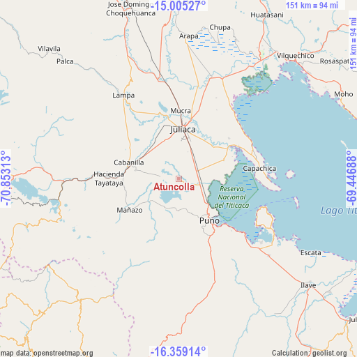
Atuncolla GPS coordinates[2]
15° 40' 59.988" South, 70° 9' 0" West
| Map corner | latitude | longitude |
|---|---|---|
| Upper-left | -15.00527°, | -70.85313° |
| Center: | -15.68333°, | -70.15° |
| Lower-right: | -16.35914°, | -69.44688° |
| Map W x H: | 150.5×150.5 km | = 93.5×93.5mi |
| max Lat: | -0.96667° ⇑91.7% North |
| Atuncolla: | -15.68333° |
| min Lat: | ⇓8.3% South -18.01465° |
| min Long | Atuncolla | max Long |
| -81.30472° | -70.15° | -69.04167° |
| W 95%⇐ | ⇒5% E |
Elevation
Elevation of Atuncolla is 3828 m = 12559 ft, and this is 1509.3 m = 4952 ft above average elevation for this country.
| Max E: |
5022 m = 16476 ft | 10.7% |
| Atuncolla | 3828 m 12559 ft | |
| Avg. | 2318.7 m = 7607 ft | |
Min E: |
1 m = 3 ft | 89.3% |
See also: Peru elevation on elevation.city.
Geographical zone
Atuncolla is located in South Torrid zone (between Equator and Tropic of Capricorn). Distance of this Southern Tropic circle is 862.1 km =535.7 mi to South.| Distance of | km | miles | from Atuncolla |
|---|---|---|---|
| Equator | 1743.8 | 1083.5 | to North |
| Tropic Capricorn | 862.1 | 535.7 | to South |
| Antarctic Circle | 5657.4 | 3515.3 | to South |
| South Pole | 8263.2 | 5134.5 | to South |


Nearby cities:
15 places around Atuncolla: (largest is in red/bold)
• Cabana
18.2 km =11.3 mi,  281°
281°
• Cabanilla
22.7 km =14.1 mi,  289°
289°
• Calapuja
41.4 km =25.7 mi,  350°
350°
• Caminaca
41.7 km =25.9 mi,  12°
12°
• Capachica
36.1 km =22.4 mi,  81°
81°
• Caracoto
14 km =8.7 mi,  22°
22°
• Coata
25 km =15.5 mi,  58°
58°
• Huata
21 km =13 mi,  69°
69°
• Juliaca
20.5 km =12.7 mi, 5°
• Mañazo
23.5 km =14.6 mi,  236°
236°
• Paucarcolla
12.1 km =7.5 mi,  117°
117°
• Puno
22.5 km =14 mi,  141°
141°
• Pusi
36.2 km =22.5 mi,  39°
39°
• Tiquillaca
15.8 km =9.8 mi,  199°
199°
• Vilque
14.2 km =8.8 mi,  229°
229°
Sources, notices
• [Note1] Compared only with cities in Peru existing in our database
• [Src1] Map data: © OpenStreetMap contributors (CC-BY-SA)
• [Src2] Other city data from geonames.org with taken over terms of usage.
• [Src3] Geographical zone / Annual Mean Temperature by Robert A. Rohde @ Wikipedia
