Ccorca geodata
Ccorca (Cusco) is a seat of a third-order administrative division; located in Peru in America/Lima (GMT-5) time zone. In our database, there are 305 cities with bigger population. Compared to other cities in Peru, 67.6% of cities are located further ↑North; 80.3% of cities are located further ←West and 84.2% of cities have lower elevation than Ccorca. Note1


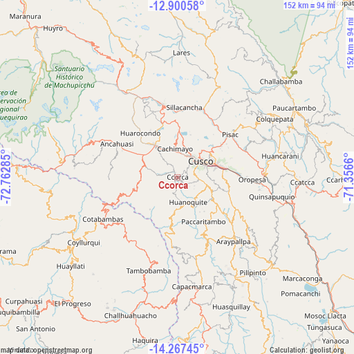
Ccorca GPS coordinates[2]
13° 35' 6" South, 72° 3' 34.992" West
| Map corner | latitude | longitude |
|---|---|---|
| Upper-left | -12.90058°, | -72.76285° |
| Center: | -13.585°, | -72.05972° |
| Lower-right: | -14.26745°, | -71.3566° |
| Map W x H: | 152×152 km | = 94.4×94.4mi |
| max Lat: | -0.96667° ⇑67.6% North |
| Ccorca: | -13.585° |
| min Lat: | ⇓32.4% South -18.01465° |
| min Long | Ccorca | max Long |
| -81.30472° | -72.05972° | -69.04167° |
| W 80.3%⇐ | ⇒19.7% E |
Elevation
Elevation of Ccorca is 3630 m = 11909 ft, and this is 1311.3 m = 4302 ft above average elevation for this country.
| Max E: |
5022 m = 16476 ft | 15.8% |
| Ccorca | 3630 m 11909 ft | |
| Avg. | 2318.7 m = 7607 ft | |
Min E: |
1 m = 3 ft | 84.2% |
See also: Peru elevation on elevation.city.
Geographical zone
Ccorca is located in South Torrid zone (between Equator and Tropic of Capricorn). Distance of this Southern Tropic circle is 1095.4 km =680.6 mi to South.| Distance of | km | miles | from Ccorca |
|---|---|---|---|
| Equator | 1510.5 | 938.6 | to North |
| Tropic Capricorn | 1095.4 | 680.6 | to South |
| Antarctic Circle | 5890.7 | 3660.3 | to South |
| South Pole | 8496.6 | 5279.5 | to South |


Nearby cities:
15 places around Ccorca: (largest is in red/bold)
• Anta
15.9 km =9.9 mi,  323°
323°
• Cachimayo
12.2 km =7.6 mi,  353°
353°
• Chinchaypujio
19.4 km =12.1 mi,  255°
255°
• Chinchero
21.5 km =13.4 mi,  3°
3°
• Cusco
12.2 km =7.6 mi,  55°
55°
• Huanoquite
11.8 km =7.3 mi,  156°
156°
• Huarocondo
24.8 km =15.4 mi, 320°
• Huayllabamba
27.5 km =17.1 mi,  358°
358°
• Paccaritambo
22.4 km =13.9 mi,  149°
149°
• Poroy
10.2 km =6.3 mi,  10°
10°
• Pucyura
13.1 km =8.1 mi,  334°
334°
• Saylla
22.9 km =14.2 mi,  83°
83°
• Taray
27.2 km =16.9 mi,  49°
49°
• Yaurisque
17.5 km =10.9 mi,  121°
121°
• Zurite
25.7 km =16 mi,  304°
304°
Sources, notices
• [Note1] Compared only with cities in Peru existing in our database
• [Src1] Map data: © OpenStreetMap contributors (CC-BY-SA)
• [Src2] Other city data from geonames.org with taken over terms of usage.
• [Src3] Geographical zone / Annual Mean Temperature by Robert A. Rohde @ Wikipedia
