Taunoa geodata
Taunoa (Îles du Vent) is a populated place; located in French Polynesia in Pacific/Tahiti (GMT-10) time zone. With population of 4,131 people, there are 12 cities with bigger population in this country. Compared to other cities in French Polynesia, 76.9% of cities are located further ↑North; 64.1% of cities are located further ←West and 87.2% of cities have higher elevation than Taunoa. Note1


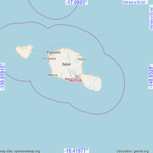
Taunoa GPS coordinates[2]
17° 45' 5.004" South, 149° 21' 21.672" West
| Map corner | latitude | longitude |
|---|---|---|
| Upper-left | -17.0805°, | -150.05915° |
| Center: | -17.75139°, | -149.35602° |
| Lower-right: | -18.41977°, | -148.6529° |
| Map W x H: | 148.9×148.9 km | = 92.5×92.5mi |
| max Lat: | -8.91093° ⇑76.9% North |
| Taunoa: | -17.75139° |
| min Lat: | ⇓23.1% South -23.34722° |
| min Long | Taunoa | max Long |
| -151.74913° | -149.35602° | -134.96858° |
| W 64.1%⇐ | ⇒35.9% E |
Elevation
Elevation of Taunoa is 3 m = 10 ft, and this is 19.6 m = 64 ft below average elevation for this country.
| Max E: |
245 m = 804 ft | 87.2% |
| Avg. | 22.6 m = 74 ft | |
| Taunoa | 3 m = 10 ft | |
Min E: |
1 m = 3 ft | 12.8% |
See also: French Polynesia elevation on elevation.city.
Geographical zone
Taunoa is located in South Torrid zone (between Equator and Tropic of Capricorn). Distance of this Southern Tropic circle is 632.1 km =392.8 mi to South.| Distance of | km | miles | from Taunoa |
|---|---|---|---|
| Equator | 1973.8 | 1226.5 | to North |
| Tropic Capricorn | 632.1 | 392.8 | to South |
| Antarctic Circle | 5427.4 | 3372.4 | to South |
| South Pole | 8033.3 | 4991.7 | to South |


Nearby cities:
15 places around Taunoa: (largest is in red/bold)
• Afaahiti
3.4 km =2.1 mi,  76°
76°
• Arue
30.2 km =18.8 mi,  329°
329°
• Faone
10.4 km =6.5 mi,  28°
28°
• Hitiaa
17.8 km =11.1 mi,  19°
19°
• Mahaena
21 km =13 mi,  11°
11°
• Otutara
6.5 km =4 mi,  249°
249°
• Paea
25.2 km =15.7 mi,  287°
287°
• Papao
20.5 km =12.7 mi,  270°
270°
• Pueu
14.1 km =8.8 mi, 84°
• Punaauia
29 km =18 mi,  296°
296°
• Tautira
20.6 km =12.8 mi,  88°
88°
• Teahupoo
14.2 km =8.8 mi,  138°
138°
• Tiarei
24.4 km =15.2 mi, 5°
• Tohautu
4.3 km =2.7 mi,  104°
104°
• Vairao
8.5 km =5.3 mi,  114°
114°
Sources, notices
• [Note1] Compared only with cities in French Polynesia existing in our database
• [Src1] Map data: © OpenStreetMap contributors (CC-BY-SA)
• [Src2] Other city data from geonames.org with taken over terms of usage.
• [Src3] Geographical zone / Annual Mean Temperature by Robert A. Rohde @ Wikipedia
