Hitiaa geodata
Hitiaa is a populated place; located in French Polynesia in Pacific/Tahiti (GMT-10) time zone. With population of 1,826 people, there are 25 cities with bigger population in this country. Compared to other cities in French Polynesia, 56.4% of cities are located further ↑North; 79.5% of cities are located further ←West and 56.4% of cities have lower elevation than Hitiaa. Note1


Hitiaa GPS coordinates[2]
17° 36' 0" South, 149° 18' 0" West
| Map corner | latitude | longitude |
|---|---|---|
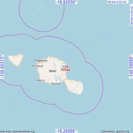
| Upper-left | -16.92856°, | -150.00313° |
| Center: | -17.6°, | -149.3° |
| Lower-right: | -18.26896°, | -148.59688° |
| Map W x H: | 149×149 km | = 92.6×92.6mi |
| max Lat: | -8.91093° ⇑56.4% North |
| Hitiaa: | -17.6° |
| min Lat: | ⇓43.6% South -23.34722° |
| min Long | Hitiaa | max Long |
| -151.74913° | -149.3° | -134.96858° |
| W 79.5%⇐ | ⇒20.5% E |
Elevation
Elevation of Hitiaa is 10 m = 33 ft, and this is 12.6 m = 41 ft below average elevation for this country.
| Max E: |
245 m = 804 ft | 43.6% |
| Avg. | 22.6 m = 74 ft | |
| Hitiaa | 10 m = 33 ft | |
Min E: |
1 m = 3 ft | 56.4% |
See also: French Polynesia elevation on elevation.city.
Geographical zone
Hitiaa is located in South Torrid zone (between Equator and Tropic of Capricorn). Distance of this Southern Tropic circle is 649 km =403.3 mi to South.| Distance of | km | miles | from Hitiaa |
|---|---|---|---|
| Equator | 1956.9 | 1216 | to North |
| Tropic Capricorn | 649 | 403.3 | to South |
| Antarctic Circle | 5444.2 | 3382.9 | to South |
| South Pole | 8050.1 | 5002.1 | to South |


Nearby cities:
15 places around Hitiaa: (largest is in red/bold)
• Afaahiti
16.2 km =10.1 mi,  189°
189°
• Arue
23.1 km =14.4 mi,  293°
293°
• Faone
7.8 km =4.8 mi, 187°
• Mahaena
4.1 km =2.5 mi,  334°
334°
• Mahina
22.6 km =14 mi,  297°
297°
• Otutara
22.6 km =14 mi,  212°
212°
• Papeete
29.1 km =18.1 mi,  283°
283°
• Pirae
26.4 km =16.4 mi, 290°
• Pueu
17.4 km =10.8 mi,  152°
152°
• Taunoa
17.8 km =11.1 mi,  199°
199°
• Tautira
22 km =13.7 mi,  138°
138°
• Teahupoo
27.6 km =17.1 mi,  172°
172°
• Tiarei
8.2 km =5.1 mi, 334°
• Tohautu
18 km =11.2 mi, 185°
• Vairao
20.5 km =12.7 mi,  175°
175°
Sources, notices
• [Note1] Compared only with cities in French Polynesia existing in our database
• [Src1] Map data: © OpenStreetMap contributors (CC-BY-SA)
• [Src2] Other city data from geonames.org with taken over terms of usage.
• [Src3] Geographical zone / Annual Mean Temperature by Robert A. Rohde @ Wikipedia
