Viga geodata
Viga (Bicol) is a seat of a third-order administrative division; located in Philippines in Asia/Manila (GMT+8) time zone. With population of 4,089 people, there are 1671 cities with bigger population in this country. Compared to other cities in Philippines, 66.9% of cities are located further ↓South; 75.7% of cities are located further ←West and 92.7% of cities have higher elevation than Viga. Note1


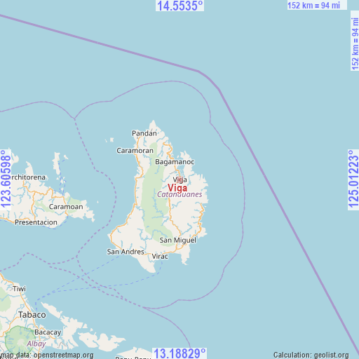
Viga GPS coordinates[2]
13° 52' 18.84" North, 124° 18' 32.76" East
| Map corner | latitude | longitude |
|---|---|---|
| Upper-left | 14.5535°, | 123.60598° |
| Center: | 13.8719°, | 124.3091° |
| Lower-right: | 13.18829°, | 125.01223° |
| Map W x H: | 151.8×151.8 km | = 94.3×94.3mi |
| max Lat: | 20.78733° ⇑33.1% North |
| Viga: | 13.8719° |
| min Lat: | ⇓66.9% South 4.65442° |
| min Long | Viga | max Long |
| 117.04868° | 124.3091° | 126.58417° |
| W 75.7%⇐ | ⇒24.3% E |
Elevation
Elevation of Viga is 6 m = 20 ft, and this is 81.9 m = 269 ft below average elevation for this country.
| Max E: |
2262 m = 7421 ft | 92.7% |
| Avg. | 87.9 m = 288 ft | |
| Viga | 6 m = 20 ft | |
Min E: |
-2 m = -7 ft | 7.3% |
See also: Philippines elevation on elevation.city.
Geographical zone
Viga is located in North Torrid zone (between Equator and Tropic of Cancer). Distance of this Northern Tropic circle is 1063.5 km =660.8 mi to North.| Distance of | km | miles | from Viga |
|---|---|---|---|
| North Pole | 8464.7 | 5259.7 | to North |
| Arctic Circle | 5858.8 | 3640.5 | to North |
| Tropic Cancer | 1063.5 | 660.8 | to North |
| Equator | 1542.4 | 958.4 | to South |


Nearby cities:
15 places around Viga: (largest is in red/bold)
• Bagamanoc
7.9 km =4.9 mi,  344°
344°
• Baras
24.6 km =15.3 mi,  164°
164°
• Bato
29.5 km =18.3 mi,  182°
182°
• Cabugao
30.8 km =19.1 mi,  185°
185°
• Calatagan
33.4 km =20.8 mi,  199°
199°
• Calolbon
38.2 km =23.7 mi,  216°
216°
• Caramoran
22.6 km =14 mi,  303°
303°
• Gigmoto
13.5 km =8.4 mi,  139°
139°
• Manamrag
26.7 km =16.6 mi,  235°
235°
• Pandan
24.5 km =15.2 mi,  321°
321°
• Panganiban
3.4 km =2.1 mi, 339°
• San Andres
37.7 km =23.4 mi, 216°
• San Miguel
25.6 km =15.9 mi, 181°
• Tubli
18.6 km =11.6 mi,  290°
290°
• Virac
32.8 km =20.4 mi, 193°
Sources, notices
• [Note1] Compared only with cities in Philippines existing in our database
• [Src1] Map data: © OpenStreetMap contributors (CC-BY-SA)
• [Src2] Other city data from geonames.org with taken over terms of usage.
• [Src3] Geographical zone / Annual Mean Temperature by Robert A. Rohde @ Wikipedia
