Gigmoto geodata
Gigmoto (Bicol) is a seat of a third-order administrative division; located in Philippines in Asia/Manila (GMT+8) time zone. With population of 3,259 people, there are 2249 cities with bigger population in this country. Compared to other cities in Philippines, 65.3% of cities are located further ↓South; 77.2% of cities are located further ←West and 92.7% of cities have higher elevation than Gigmoto. Note1


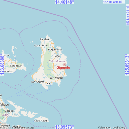
Gigmoto GPS coordinates[2]
13° 46' 46.56" North, 124° 23' 24" East
| Map corner | latitude | longitude |
|---|---|---|
| Upper-left | 14.46148°, | 123.68688° |
| Center: | 13.7796°, | 124.39° |
| Lower-right: | 13.09573°, | 125.09313° |
| Map W x H: | 151.9×151.9 km | = 94.4×94.4mi |
| max Lat: | 20.78733° ⇑34.7% North |
| Gigmoto: | 13.7796° |
| min Lat: | ⇓65.3% South 4.65442° |
| min Long | Gigmoto | max Long |
| 117.04868° | 124.39° | 126.58417° |
| W 77.2%⇐ | ⇒22.8% E |
Elevation
Elevation of Gigmoto is 6 m = 20 ft, and this is 81.9 m = 269 ft below average elevation for this country.
| Max E: |
2262 m = 7421 ft | 92.7% |
| Avg. | 87.9 m = 288 ft | |
| Gigmoto | 6 m = 20 ft | |
Min E: |
-2 m = -7 ft | 7.3% |
See also: Philippines elevation on elevation.city.
Geographical zone
Gigmoto is located in North Torrid zone (between Equator and Tropic of Cancer). Distance of this Northern Tropic circle is 1073.8 km =667.2 mi to North.| Distance of | km | miles | from Gigmoto |
|---|---|---|---|
| North Pole | 8474.9 | 5266.1 | to North |
| Arctic Circle | 5869 | 3646.8 | to North |
| Tropic Cancer | 1073.8 | 667.2 | to North |
| Equator | 1532.1 | 952 | to South |


Nearby cities:
15 places around Gigmoto: (largest is in red/bold)
• Bagamanoc
20.9 km =13 mi,  328°
328°
• Baras
13.6 km =8.5 mi,  189°
189°
• Bato
21.6 km =13.4 mi,  207°
207°
• Cabugao
23.6 km =14.7 mi, 210°
• Calatagan
29.1 km =18.1 mi,  223°
223°
• Calolbon
37.5 km =23.3 mi,  236°
236°
• Caramoran
35.8 km =22.2 mi,  309°
309°
• Manamrag
31 km =19.3 mi,  260°
260°
• Pandan
37.9 km =23.5 mi,  321°
321°
• Panganiban
16.7 km =10.4 mi, 323°
• San Andres
37.2 km =23.1 mi, 237°
• San Miguel
18 km =11.2 mi, 211°
• Tubli
31.1 km =19.3 mi,  302°
302°
• Viga
13.5 km =8.4 mi, 319°
• Virac
27.2 km =16.9 mi, 217°
Sources, notices
• [Note1] Compared only with cities in Philippines existing in our database
• [Src1] Map data: © OpenStreetMap contributors (CC-BY-SA)
• [Src2] Other city data from geonames.org with taken over terms of usage.
• [Src3] Geographical zone / Annual Mean Temperature by Robert A. Rohde @ Wikipedia
