Uyaan geodata
Uyaan (Autonomous Region in Muslim Mindanao) is a populated place; located in Philippines in Asia/Manila (GMT+8) time zone. With population of 2,601 people, there are 3103 cities with bigger population in this country. Compared to other cities in Philippines, 83.7% of cities are located further ↑North; 72% of cities are located further ←West and 99.2% of cities have lower elevation than Uyaan. Note1
Administrative division(s):
- Level 1: Autonomous Region in Muslim Mindanao
- Level 2: Province of Lanao del Sur
- Level 3: Madamba


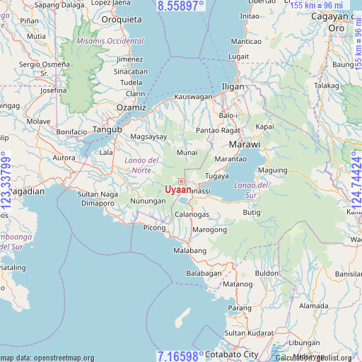
Uyaan GPS coordinates[2]
7° 51' 47.016" North, 124° 2' 27.996" East
| Map corner | latitude | longitude |
|---|---|---|
| Upper-left | 8.55897°, | 123.33799° |
| Center: | 7.86306°, | 124.04111° |
| Lower-right: | 7.16598°, | 124.74424° |
| Map W x H: | 154.9×154.9 km | = 96.3×96.3mi |
| max Lat: | 20.78733° ⇑83.7% North |
| Uyaan: | 7.86306° |
| min Lat: | ⇓16.3% South 4.65442° |
| min Long | Uyaan | max Long |
| 117.04868° | 124.04111° | 126.58417° |
| W 72%⇐ | ⇒28% E |
Elevation
Elevation of Uyaan is 1123 m = 3684 ft, and this is 1035.1 m = 3396 ft above average elevation for this country.
| Max E: |
2262 m = 7421 ft | 0.8% |
| Uyaan | 1123 m 3684 ft | |
| Avg. | 87.9 m = 288 ft | |
Min E: |
-2 m = -7 ft | 99.2% |
See also: Philippines elevation on elevation.city.
Geographical zone
Uyaan is located in North Torrid zone (between Equator and Tropic of Cancer). Distance of Equator is 874.3 km =543.3 mi to South.| Distance of | km | miles | from Uyaan |
|---|---|---|---|
| North Pole | 9132.8 | 5674.9 | to North |
| Arctic Circle | 6526.9 | 4055.6 | to North |
| Tropic Cancer | 1731.6 | 1076 | to North |
| Equator | 874.3 | 543.3 | to South |


Nearby cities:
15 places around Uyaan: (largest is in red/bold)
• Bacayawan
23.7 km =14.7 mi,  116°
116°
• Balindong
18.5 km =11.5 mi,  71°
71°
• Bayang
18.3 km =11.4 mi, 115°
• Binidayan
15.4 km =9.6 mi,  114°
114°
• Calanogas
14.1 km =8.8 mi,  152°
152°
• Ganassi
8 km =5 mi, 120°
• Madalum
8.8 km =5.5 mi,  96°
96°
• Madamba
8.1 km =5 mi, 109°
• Marantao
23.3 km =14.5 mi, 65°
• Munai
12.8 km =8 mi,  11°
11°
• Pualas
6.2 km =3.9 mi, 147°
• Salvador
22 km =13.7 mi,  279°
279°
• Sapad
22.9 km =14.2 mi,  266°
266°
• Tubaran
17.5 km =10.9 mi,  127°
127°
• Tugaya
14.8 km =9.2 mi,  81°
81°
Sources, notices
• [Note1] Compared only with cities in Philippines existing in our database
• [Src1] Map data: © OpenStreetMap contributors (CC-BY-SA)
• [Src2] Other city data from geonames.org with taken over terms of usage.
• [Src3] Geographical zone / Annual Mean Temperature by Robert A. Rohde @ Wikipedia
