Munai geodata
Munai (Northern Mindanao) is a seat of a third-order administrative division; located in Philippines in Asia/Manila (GMT+8) time zone. With population of 2,113 people, there are 4052 cities with bigger population in this country. Compared to other cities in Philippines, 83% of cities are located further ↑North; 72.4% of cities are located further ←West and 96.6% of cities have lower elevation than Munai. Note1
Administrative division(s):
- Level 1: Northern Mindanao
- Level 2: Province of Lanao del Norte
- Level 3: Munai


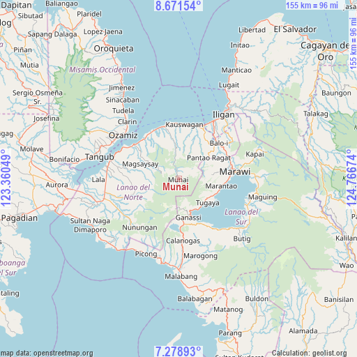
Munai GPS coordinates[2]
7° 58' 32.988" North, 124° 3' 48.996" East
| Map corner | latitude | longitude |
|---|---|---|
| Upper-left | 8.67154°, | 123.36049° |
| Center: | 7.97583°, | 124.06361° |
| Lower-right: | 7.27893°, | 124.76674° |
| Map W x H: | 154.8×154.8 km | = 96.2×96.2mi |
| max Lat: | 20.78733° ⇑83% North |
| Munai: | 7.97583° |
| min Lat: | ⇓17% South 4.65442° |
| min Long | Munai | max Long |
| 117.04868° | 124.06361° | 126.58417° |
| W 72.4%⇐ | ⇒27.6% E |
Elevation
Elevation of Munai is 565 m = 1854 ft, and this is 477.1 m = 1565 ft above average elevation for this country.
| Max E: |
2262 m = 7421 ft | 3.4% |
| Munai | 565 m 1854 ft | |
| Avg. | 87.9 m = 288 ft | |
Min E: |
-2 m = -7 ft | 96.6% |
See also: Philippines elevation on elevation.city.
Geographical zone
Munai is located in North Torrid zone (between Equator and Tropic of Cancer). Distance of Equator is 886.8 km =551 mi to South.| Distance of | km | miles | from Munai |
|---|---|---|---|
| North Pole | 9120.2 | 5667 | to North |
| Arctic Circle | 6514.3 | 4047.8 | to North |
| Tropic Cancer | 1719.1 | 1068.2 | to North |
| Equator | 886.8 | 551 | to South |


Nearby cities:
15 places around Munai: (largest is in red/bold)
• Bacolod
22.5 km =14 mi,  314°
314°
• Balindong
16.4 km =10.2 mi,  113°
113°
• Binidayan
22.1 km =13.7 mi,  148°
148°
• Dimayon
13.9 km =8.6 mi,  43°
43°
• Ganassi
17.1 km =10.6 mi,  165°
165°
• Madalum
14.9 km =9.3 mi,  155°
155°
• Madamba
16.1 km =10 mi, 161°
• Marantao
18.9 km =11.7 mi,  98°
98°
• Matungao
21 km =13 mi,  31°
31°
• Pantao-Ragat
14.2 km =8.8 mi, 32°
• Pawak
21.7 km =13.5 mi,  78°
78°
• Poona-Piagapo
13.3 km =8.3 mi, 26°
• Pualas
17.8 km =11.1 mi,  177°
177°
• Tugaya
16 km =9.9 mi,  130°
130°
• Uyaan
12.8 km =8 mi,  191°
191°
Sources, notices
• [Note1] Compared only with cities in Philippines existing in our database
• [Src1] Map data: © OpenStreetMap contributors (CC-BY-SA)
• [Src2] Other city data from geonames.org with taken over terms of usage.
• [Src3] Geographical zone / Annual Mean Temperature by Robert A. Rohde @ Wikipedia
