Sapad geodata
Sapad (Soccsksargen) is a populated place; located in Philippines in Asia/Manila (GMT+8) time zone. With population of 4,471 people, there are 1508 cities with bigger population in this country. Compared to other cities in Philippines, 83.9% of cities are located further ↑North; 68.3% of cities are located further ←West and 62.9% of cities have lower elevation than Sapad. Note1


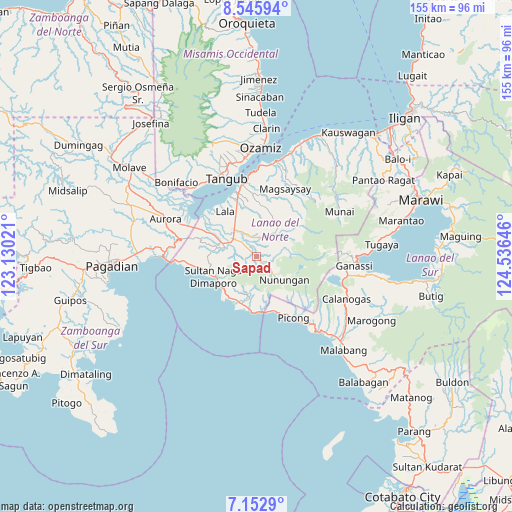
Sapad GPS coordinates[2]
7° 51' 0" North, 123° 49' 59.988" East
| Map corner | latitude | longitude |
|---|---|---|
| Upper-left | 8.54594°, | 123.13021° |
| Center: | 7.85°, | 123.83333° |
| Lower-right: | 7.1529°, | 124.53646° |
| Map W x H: | 154.9×154.9 km | = 96.3×96.3mi |
| max Lat: | 20.78733° ⇑83.9% North |
| Sapad: | 7.85° |
| min Lat: | ⇓16.1% South 4.65442° |
| min Long | Sapad | max Long |
| 117.04868° | 123.83333° | 126.58417° |
| W 68.3%⇐ | ⇒31.7% E |
Elevation
Elevation of Sapad is 38 m = 125 ft, and this is 49.9 m = 164 ft below average elevation for this country.
| Max E: |
2262 m = 7421 ft | 37.1% |
| Avg. | 87.9 m = 288 ft | |
| Sapad | 38 m = 125 ft | |
Min E: |
-2 m = -7 ft | 62.9% |
See also: Philippines elevation on elevation.city.
Geographical zone
Sapad is located in North Torrid zone (between Equator and Tropic of Cancer). Distance of Equator is 872.8 km =542.3 mi to South.| Distance of | km | miles | from Sapad |
|---|---|---|---|
| North Pole | 9134.2 | 5675.7 | to North |
| Arctic Circle | 6528.3 | 4056.5 | to North |
| Tropic Cancer | 1733.1 | 1076.9 | to North |
| Equator | 872.8 | 542.3 | to South |


Nearby cities:
15 places around Sapad: (largest is in red/bold)
• Balili
12.1 km =7.5 mi,  294°
294°
• Baroy
20.6 km =12.8 mi,  342°
342°
• Caromatan
14.4 km =8.9 mi,  245°
245°
• Kapatagan
9 km =5.6 mi,  308°
308°
• Lala
16.6 km =10.3 mi,  325°
325°
• Lanipao
13.3 km =8.3 mi, 331°
• Lapining
17.9 km =11.1 mi,  296°
296°
• Maranding
10.7 km =6.6 mi,  320°
320°
• Margos
21.3 km =13.2 mi, 295°
• Panalo-on
11.8 km =7.3 mi, 308°
• Pualas
18.7 km =11.6 mi,  4°
4°
• Rebe
6.7 km =4.2 mi, 342°
• Salvador
5.2 km =3.2 mi,  12°
12°
• Tubod
23.3 km =14.5 mi,  348°
348°
• Uyaan
22.9 km =14.2 mi,  86°
86°
Sources, notices
• [Note1] Compared only with cities in Philippines existing in our database
• [Src1] Map data: © OpenStreetMap contributors (CC-BY-SA)
• [Src2] Other city data from geonames.org with taken over terms of usage.
• [Src3] Geographical zone / Annual Mean Temperature by Robert A. Rohde @ Wikipedia
