Tamiso geodata
Tamiso (Central Visayas) is a populated place; located in Philippines in Asia/Manila (GMT+8) time zone. With population of 2,904 people, there are 2638 cities with bigger population in this country. Compared to other cities in Philippines, 72.3% of cities are located further ↑North; 54.8% of cities are located further ←West and 77.2% of cities have lower elevation than Tamiso. Note1
Administrative division(s):
- Level 1: Central Visayas
- Level 2: Province of Negros Oriental
- Level 3: Bais City


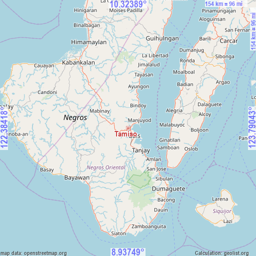
Tamiso GPS coordinates[2]
9° 37' 53.04" North, 123° 5' 14.28" East
| Map corner | latitude | longitude |
|---|---|---|
| Upper-left | 10.32389°, | 122.38418° |
| Center: | 9.6314°, | 123.0873° |
| Lower-right: | 8.93749°, | 123.79043° |
| Map W x H: | 154.2×154.2 km | = 95.8×95.8mi |
| max Lat: | 20.78733° ⇑72.3% North |
| Tamiso: | 9.6314° |
| min Lat: | ⇓27.7% South 4.65442° |
| min Long | Tamiso | max Long |
| 117.04868° | 123.0873° | 126.58417° |
| W 54.8%⇐ | ⇒45.2% E |
Elevation
Elevation of Tamiso is 76 m = 249 ft, and this is 11.9 m = 39 ft below average elevation for this country.
| Max E: |
2262 m = 7421 ft | 22.8% |
| Avg. | 87.9 m = 288 ft | |
| Tamiso | 76 m = 249 ft | |
Min E: |
-2 m = -7 ft | 77.2% |
See also: Philippines elevation on elevation.city.
Geographical zone
Tamiso is located in North Torrid zone (between Equator and Tropic of Cancer). Distance of Equator is 1070.9 km =665.4 mi to South.| Distance of | km | miles | from Tamiso |
|---|---|---|---|
| North Pole | 8936.2 | 5552.7 | to North |
| Arctic Circle | 6330.3 | 3933.5 | to North |
| Tropic Cancer | 1535 | 953.8 | to North |
| Equator | 1070.9 | 665.4 | to South |


Nearby cities:
15 places around Tamiso: (largest is in red/bold)
• Alangilanan
2.4 km =1.5 mi,  59°
59°
• Bagtic
10.3 km =6.4 mi,  306°
306°
• Bais
5.9 km =3.7 mi,  139°
139°
• Balayong
17.7 km =11 mi,  188°
188°
• Bolisong
9.7 km =6 mi,  46°
46°
• Bulod
9 km =5.6 mi, 49°
• Campoyo
7.2 km =4.5 mi,  67°
67°
• Kandabong
6.3 km =3.9 mi,  345°
345°
• Mayapusi
7.6 km =4.7 mi,  263°
263°
• Nalundan
13.4 km =8.3 mi, 350°
• Novallas
13.9 km =8.6 mi,  163°
163°
• Okiot
11.3 km =7 mi,  129°
129°
• Payabon
15.4 km =9.6 mi,  22°
22°
• Santa Cruz
10.9 km =6.8 mi,  169°
169°
• Tanjay
15 km =9.3 mi,  148°
148°
Sources, notices
• [Note1] Compared only with cities in Philippines existing in our database
• [Src1] Map data: © OpenStreetMap contributors (CC-BY-SA)
• [Src2] Other city data from geonames.org with taken over terms of usage.
• [Src3] Geographical zone / Annual Mean Temperature by Robert A. Rohde @ Wikipedia
