Okiot geodata
Okiot (Central Visayas) is a populated place; located in Philippines in Asia/Manila (GMT+8) time zone. With population of 3,370 people, there are 2169 cities with bigger population in this country. Compared to other cities in Philippines, 72.9% of cities are located further ↑North; 56.2% of cities are located further ←West and 92.7% of cities have higher elevation than Okiot. Note1


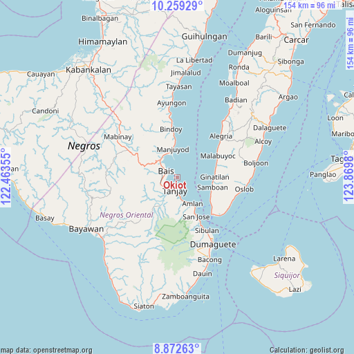
Okiot GPS coordinates[2]
9° 34' 0.012" North, 123° 10' 0.012" East
| Map corner | latitude | longitude |
|---|---|---|
| Upper-left | 10.25929°, | 122.46355° |
| Center: | 9.56667°, | 123.16667° |
| Lower-right: | 8.87263°, | 123.8698° |
| Map W x H: | 154.2×154.2 km | = 95.8×95.8mi |
| max Lat: | 20.78733° ⇑72.9% North |
| Okiot: | 9.56667° |
| min Lat: | ⇓27.1% South 4.65442° |
| min Long | Okiot | max Long |
| 117.04868° | 123.16667° | 126.58417° |
| W 56.2%⇐ | ⇒43.8% E |
Elevation
Elevation of Okiot is 6 m = 20 ft, and this is 81.9 m = 269 ft below average elevation for this country.
| Max E: |
2262 m = 7421 ft | 92.7% |
| Avg. | 87.9 m = 288 ft | |
| Okiot | 6 m = 20 ft | |
Min E: |
-2 m = -7 ft | 7.3% |
See also: Philippines elevation on elevation.city.
Geographical zone
Okiot is located in North Torrid zone (between Equator and Tropic of Cancer). Distance of Equator is 1063.7 km =661 mi to South.| Distance of | km | miles | from Okiot |
|---|---|---|---|
| North Pole | 8943.3 | 5557.1 | to North |
| Arctic Circle | 6337.5 | 3937.9 | to North |
| Tropic Cancer | 1542.2 | 958.3 | to North |
| Equator | 1063.7 | 661 | to South |


Nearby cities:
15 places around Okiot: (largest is in red/bold)
• Alangilanan
10.7 km =6.6 mi,  321°
321°
• Azagra
10.4 km =6.5 mi,  198°
198°
• Bais
5.5 km =3.4 mi,  299°
299°
• Bolisong
13.9 km =8.6 mi,  353°
353°
• Bulod
13.1 km =8.1 mi, 351°
• Campoyo
10.2 km =6.3 mi, 348°
• Jantianon
13.6 km =8.5 mi,  180°
180°
• Jugno
11.7 km =7.3 mi,  159°
159°
• Novallas
7.8 km =4.8 mi,  218°
218°
• Pamplona
11.7 km =7.3 mi,  206°
206°
• Polo
9.6 km =6 mi,  171°
171°
• Santa Cruz
7.6 km =4.7 mi,  242°
242°
• Tamiso
11.3 km =7 mi,  309°
309°
• Tandayag
14.3 km =8.9 mi,  150°
150°
• Tanjay
5.7 km =3.5 mi,  189°
189°
Sources, notices
• [Note1] Compared only with cities in Philippines existing in our database
• [Src1] Map data: © OpenStreetMap contributors (CC-BY-SA)
• [Src2] Other city data from geonames.org with taken over terms of usage.
• [Src3] Geographical zone / Annual Mean Temperature by Robert A. Rohde @ Wikipedia
