Surigao geodata
Surigao (Caraga) is a seat of a second-order administrative division; located in Philippines in Asia/Manila (GMT+8) time zone. With population of 87,832 people, there are 103 cities with bigger population in this country. Compared to other cities in Philippines, 70.5% of cities are located further ↑North; 93.4% of cities are located further ←West and 76.6% of cities have higher elevation than Surigao. Note1
Administrative division(s):
- Level 1: Caraga
- Level 2: Province of Surigao del Norte
- Level 3: Surigao City


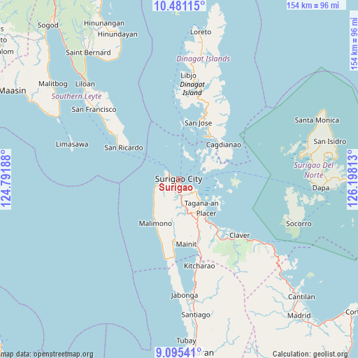
Surigao GPS coordinates[2]
9° 47' 20.4" North, 125° 29' 42" East
| Map corner | latitude | longitude |
|---|---|---|
| Upper-left | 10.48115°, | 124.79188° |
| Center: | 9.789°, | 125.495° |
| Lower-right: | 9.09541°, | 126.19813° |
| Map W x H: | 154.1×154.1 km | = 95.8×95.8mi |
| max Lat: | 20.78733° ⇑70.5% North |
| Surigao: | 9.789° |
| min Lat: | ⇓29.5% South 4.65442° |
| min Long | Surigao | max Long |
| 117.04868° | 125.495° | 126.58417° |
| W 93.4%⇐ | ⇒6.6% E |
Elevation
Elevation of Surigao is 10 m = 33 ft, and this is 77.9 m = 256 ft below average elevation for this country.
| Max E: |
2262 m = 7421 ft | 76.6% |
| Avg. | 87.9 m = 288 ft | |
| Surigao | 10 m = 33 ft | |
Min E: |
-2 m = -7 ft | 23.4% |
See also: Surigao elevation on elevation.city.
Geographical zone
Surigao is located in North Torrid zone (between Equator and Tropic of Cancer). Distance of Equator is 1088.4 km =676.3 mi to South.| Distance of | km | miles | from Surigao |
|---|---|---|---|
| North Pole | 8918.6 | 5541.8 | to North |
| Arctic Circle | 6312.7 | 3922.5 | to North |
| Tropic Cancer | 1517.5 | 942.9 | to North |
| Equator | 1088.4 | 676.3 | to South |


Nearby cities:
15 places around Surigao: (largest is in red/bold)
• Basilisa
23.5 km =14.6 mi,  1°
1°
• Cagdianao
24.1 km =15 mi,  52°
52°
• Capalayan
7.6 km =4.7 mi,  134°
134°
• Dinagat
21.5 km =13.4 mi,  30°
30°
• Ipil
6.2 km =3.9 mi,  271°
271°
• Luna
5.8 km =3.6 mi,  177°
177°
• Mabua
6.2 km =3.9 mi,  285°
285°
• Malimono
21.6 km =13.4 mi,  208°
208°
• Mati
6.6 km =4.1 mi, 206°
• Placer
19.1 km =11.9 mi,  141°
141°
• Rizal
3.5 km =2.2 mi,  254°
254°
• San Francisco
7.8 km =4.8 mi,  260°
260°
• Sison
14.8 km =9.2 mi,  165°
165°
• Tagana-an
14.2 km =8.8 mi, 135°
• Talisay
13.6 km =8.5 mi,  75°
75°
Sources, notices
• [Note1] Compared only with cities in Philippines existing in our database
• [Src1] Map data: © OpenStreetMap contributors (CC-BY-SA)
• [Src2] Other city data from geonames.org with taken over terms of usage.
• [Src3] Geographical zone / Annual Mean Temperature by Robert A. Rohde @ Wikipedia
