Sison geodata
Sison (Caraga) is a seat of a third-order administrative division; located in Philippines in Asia/Manila (GMT+8) time zone. With population of 3,171 people, there are 2332 cities with bigger population in this country. Compared to other cities in Philippines, 71.9% of cities are located further ↑North; 93.8% of cities are located further ←West and 62.2% of cities have lower elevation than Sison. Note1


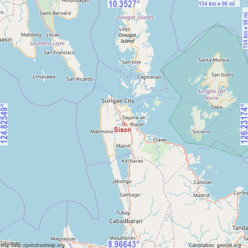
Sison GPS coordinates[2]
9° 39' 37.008" North, 125° 31' 42.996" East
| Map corner | latitude | longitude |
|---|---|---|
| Upper-left | 10.3527°, | 124.82549° |
| Center: | 9.66028°, | 125.52861° |
| Lower-right: | 8.96643°, | 126.23174° |
| Map W x H: | 154.1×154.1 km | = 95.8×95.8mi |
| max Lat: | 20.78733° ⇑71.9% North |
| Sison: | 9.66028° |
| min Lat: | ⇓28.1% South 4.65442° |
| min Long | Sison | max Long |
| 117.04868° | 125.52861° | 126.58417° |
| W 93.8%⇐ | ⇒6.2% E |
Elevation
Elevation of Sison is 37 m = 121 ft, and this is 50.9 m = 167 ft below average elevation for this country.
| Max E: |
2262 m = 7421 ft | 37.8% |
| Avg. | 87.9 m = 288 ft | |
| Sison | 37 m = 121 ft | |
Min E: |
-2 m = -7 ft | 62.2% |
See also: Philippines elevation on elevation.city.
Geographical zone
Sison is located in North Torrid zone (between Equator and Tropic of Cancer). Distance of Equator is 1074.1 km =667.4 mi to South.| Distance of | km | miles | from Sison |
|---|---|---|---|
| North Pole | 8932.9 | 5550.6 | to North |
| Arctic Circle | 6327.1 | 3931.5 | to North |
| Tropic Cancer | 1531.8 | 951.8 | to North |
| Equator | 1074.1 | 667.4 | to South |


Nearby cities:
15 places around Sison: (largest is in red/bold)
• Bacuag
13.4 km =8.3 mi,  115°
115°
• Capalayan
9.1 km =5.7 mi,  10°
10°
• Ipil
17.5 km =10.9 mi,  325°
325°
• Luna
9.2 km =5.7 mi,  338°
338°
• Mabua
18.6 km =11.6 mi, 328°
• Mainit
13.9 km =8.6 mi,  182°
182°
• Malimono
14.6 km =9.1 mi,  251°
251°
• Mati
10.7 km =6.6 mi,  321°
321°
• Placer
8.1 km =5 mi,  94°
94°
• Rizal
15.1 km =9.4 mi, 332°
• San Francisco
15.4 km =9.6 mi,  197°
197°
• San Francisco
17.3 km =10.7 mi, 318°
• Surigao
14.8 km =9.2 mi,  345°
345°
• Tagana-an
7.5 km =4.7 mi,  56°
56°
• Tubod
11.8 km =7.3 mi,  156°
156°
Sources, notices
• [Note1] Compared only with cities in Philippines existing in our database
• [Src1] Map data: © OpenStreetMap contributors (CC-BY-SA)
• [Src2] Other city data from geonames.org with taken over terms of usage.
• [Src3] Geographical zone / Annual Mean Temperature by Robert A. Rohde @ Wikipedia
