Solsona geodata
Solsona (Ilocos) is a seat of a third-order administrative division; located in Philippines in Asia/Manila (GMT+8) time zone. With population of 3,726 people, there are 1897 cities with bigger population in this country. Compared to other cities in Philippines, 98.6% of cities are located further ↓South; 83.1% of cities are located further →East and 70% of cities have lower elevation than Solsona. Note1


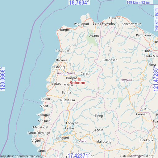
Solsona GPS coordinates[2]
18° 5' 35.988" North, 120° 46' 10.992" East
| Map corner | latitude | longitude |
|---|---|---|
| Upper-left | 18.7604°, | 120.0666° |
| Center: | 18.09333°, | 120.76972° |
| Lower-right: | 17.42371°, | 121.47285° |
| Map W x H: | 148.6×148.6 km | = 92.3×92.3mi |
| max Lat: | 20.78733° ⇑1.4% North |
| Solsona: | 18.09333° |
| min Lat: | ⇓98.6% South 4.65442° |
| min Long | Solsona | max Long |
| 117.04868° | 120.76972° | 126.58417° |
| W 16.9%⇐ | ⇒83.1% E |
Elevation
Elevation of Solsona is 52 m = 171 ft, and this is 35.9 m = 118 ft below average elevation for this country.
| Max E: |
2262 m = 7421 ft | 30% |
| Avg. | 87.9 m = 288 ft | |
| Solsona | 52 m = 171 ft | |
Min E: |
-2 m = -7 ft | 70% |
See also: Philippines elevation on elevation.city.
Geographical zone
Solsona is located in North Torrid zone (between Equator and Tropic of Cancer). Distance of this Northern Tropic circle is 594.1 km =369.2 mi to North.| Distance of | km | miles | from Solsona |
|---|---|---|---|
| North Pole | 7995.3 | 4968 | to North |
| Arctic Circle | 5389.4 | 3348.8 | to North |
| Tropic Cancer | 594.1 | 369.2 | to North |
| Equator | 2011.8 | 1250.1 | to South |


Nearby cities:
15 places around Solsona: (largest is in red/bold)
• Baay
20.7 km =12.9 mi,  277°
277°
• Barong
5.5 km =3.4 mi,  223°
223°
• Batac City
22.1 km =13.7 mi,  258°
258°
• Bil-Loca
21.3 km =13.2 mi,  268°
268°
• Carasi
15.7 km =9.8 mi,  41°
41°
• Dingras
7.8 km =4.8 mi, 278°
• Espiritu
17.3 km =10.7 mi, 223°
• Laoag
21.7 km =13.5 mi,  302°
302°
• Marcos
9.6 km =6 mi,  241°
241°
• Padong
4.6 km =2.9 mi,  200°
200°
• Piddig
9.7 km =6 mi,  325°
325°
• San Lorenzo
15.3 km =9.5 mi,  286°
286°
• San Nicolas
20.4 km =12.7 mi, 295°
• Sarrat
14.8 km =9.2 mi, 298°
• Vintar
19.8 km =12.3 mi,  319°
319°
Sources, notices
• [Note1] Compared only with cities in Philippines existing in our database
• [Src1] Map data: © OpenStreetMap contributors (CC-BY-SA)
• [Src2] Other city data from geonames.org with taken over terms of usage.
• [Src3] Geographical zone / Annual Mean Temperature by Robert A. Rohde @ Wikipedia
