Vintar geodata
Vintar (Ilocos) is a populated place; located in Philippines in Asia/Manila (GMT+8) time zone. With population of 5,263 people, there are 1212 cities with bigger population in this country. Compared to other cities in Philippines, 99% of cities are located further ↓South; 86.6% of cities are located further →East and 56.6% of cities have lower elevation than Vintar. Note1


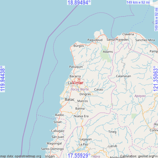
Vintar GPS coordinates[2]
18° 13' 42.24" North, 120° 38' 51" East
| Map corner | latitude | longitude |
|---|---|---|
| Upper-left | 18.89494°, | 119.94438° |
| Center: | 18.2284°, | 120.6475° |
| Lower-right: | 17.55929°, | 121.35063° |
| Map W x H: | 148.5×148.5 km | = 92.3×92.3mi |
| max Lat: | 20.78733° ⇑1% North |
| Vintar: | 18.2284° |
| min Lat: | ⇓99% South 4.65442° |
| min Long | Vintar | max Long |
| 117.04868° | 120.6475° | 126.58417° |
| W 13.4%⇐ | ⇒86.6% E |
Elevation
Elevation of Vintar is 29 m = 95 ft, and this is 58.9 m = 193 ft below average elevation for this country.
| Max E: |
2262 m = 7421 ft | 43.4% |
| Avg. | 87.9 m = 288 ft | |
| Vintar | 29 m = 95 ft | |
Min E: |
-2 m = -7 ft | 56.6% |
See also: Philippines elevation on elevation.city.
Geographical zone
Vintar is located in North Torrid zone (between Equator and Tropic of Cancer). Distance of this Northern Tropic circle is 579.1 km =359.8 mi to North.| Distance of | km | miles | from Vintar |
|---|---|---|---|
| North Pole | 7980.3 | 4958.7 | to North |
| Arctic Circle | 5374.4 | 3339.5 | to North |
| Tropic Cancer | 579.1 | 359.8 | to North |
| Equator | 2026.8 | 1259.4 | to South |


Nearby cities:
15 places around Vintar: (largest is in red/bold)
• Baay
14.4 km =8.9 mi,  212°
212°
• Bacarra
4.6 km =2.9 mi,  306°
306°
• Barong
21.1 km =13.1 mi,  154°
154°
• Bil-Loca
17.7 km =11 mi, 207°
• Dingras
14.9 km =9.3 mi,  159°
159°
• Laoag
6.4 km =4 mi,  238°
238°
• Marcos
20.1 km =12.5 mi,  167°
167°
• Nagbacalan
18.1 km =11.2 mi,  226°
226°
• Pasuquin
12 km =7.5 mi,  344°
344°
• Piddig
10.2 km =6.3 mi,  133°
133°
• Quiling
20.9 km =13 mi, 211°
• San Lorenzo
10.8 km =6.7 mi,  189°
189°
• San Nicolas
8.3 km =5.2 mi,  221°
221°
• Sarrat
7.9 km =4.9 mi,  180°
180°
• Solsona
19.8 km =12.3 mi,  139°
139°
Sources, notices
• [Note1] Compared only with cities in Philippines existing in our database
• [Src1] Map data: © OpenStreetMap contributors (CC-BY-SA)
• [Src2] Other city data from geonames.org with taken over terms of usage.
• [Src3] Geographical zone / Annual Mean Temperature by Robert A. Rohde @ Wikipedia
