San Vicente geodata
San Vicente (Bicol) is a populated place; located in Philippines in Asia/Manila (GMT+8) time zone. With population of 4,297 people, there are 1587 cities with bigger population in this country. Compared to other cities in Philippines, 61.2% of cities are located further ↓South; 60.8% of cities are located further ←West and 52.3% of cities have lower elevation than San Vicente. Note1


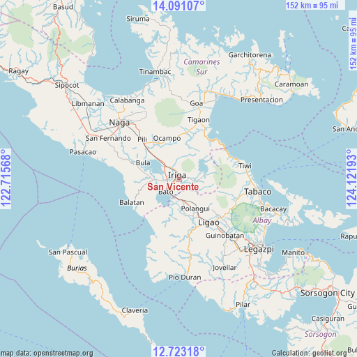
San Vicente GPS coordinates[2]
13° 24' 29.16" North, 123° 25' 7.68" East
| Map corner | latitude | longitude |
|---|---|---|
| Upper-left | 14.09107°, | 122.71568° |
| Center: | 13.4081°, | 123.4188° |
| Lower-right: | 12.72318°, | 124.12193° |
| Map W x H: | 152.1×152.1 km | = 94.5×94.5mi |
| max Lat: | 20.78733° ⇑38.8% North |
| San Vicente: | 13.4081° |
| min Lat: | ⇓61.2% South 4.65442° |
| min Long | San Vicente | max Long |
| 117.04868° | 123.4188° | 126.58417° |
| W 60.8%⇐ | ⇒39.2% E |
Elevation
Elevation of San Vicente is 25 m = 82 ft, and this is 62.9 m = 206 ft below average elevation for this country.
| Max E: |
2262 m = 7421 ft | 47.7% |
| Avg. | 87.9 m = 288 ft | |
| San Vicente | 25 m = 82 ft | |
Min E: |
-2 m = -7 ft | 52.3% |
See also: Philippines elevation on elevation.city.
Geographical zone
San Vicente is located in North Torrid zone (between Equator and Tropic of Cancer). Distance of this Northern Tropic circle is 1115.1 km =692.9 mi to North.| Distance of | km | miles | from San Vicente |
|---|---|---|---|
| North Pole | 8516.2 | 5291.7 | to North |
| Arctic Circle | 5910.3 | 3672.5 | to North |
| Tropic Cancer | 1115.1 | 692.9 | to North |
| Equator | 1490.8 | 926.3 | to South |


Nearby cities:
15 places around San Vicente: (largest is in red/bold)
• Agos
7.5 km =4.7 mi,  197°
197°
• Baao
7.8 km =4.8 mi,  311°
311°
• Bagumbayan
7.1 km =4.4 mi,  333°
333°
• Bato
8.3 km =5.2 mi,  221°
221°
• Iriga City
2.8 km =1.7 mi,  343°
343°
• Lourdes
5.3 km =3.3 mi,  247°
247°
• Masoli
6.3 km =3.9 mi,  210°
210°
• Nabua
5 km =3.1 mi,  269°
269°
• Salvacion
7.7 km =4.8 mi,  323°
323°
• San Antonio
4.1 km =2.5 mi,  177°
177°
• San Miguel
1.7 km =1.1 mi, 318°
• San Vicente
7 km =4.3 mi, 314°
• Santa Justina
6 km =3.7 mi,  102°
102°
• Santa Teresita
7.8 km =4.8 mi,  0°
0°
• Santo Domingo
3.5 km =2.2 mi,  67°
67°
Sources, notices
• [Note1] Compared only with cities in Philippines existing in our database
• [Src1] Map data: © OpenStreetMap contributors (CC-BY-SA)
• [Src2] Other city data from geonames.org with taken over terms of usage.
• [Src3] Geographical zone / Annual Mean Temperature by Robert A. Rohde @ Wikipedia
