San Antonio geodata
San Antonio (Bicol) is a populated place; located in Philippines in Asia/Manila (GMT+8) time zone. With population of 4,374 people, there are 1552 cities with bigger population in this country. Compared to other cities in Philippines, 60.9% of cities are located further ↓South; 60.8% of cities are located further ←West and 65.2% of cities have lower elevation than San Antonio. Note1


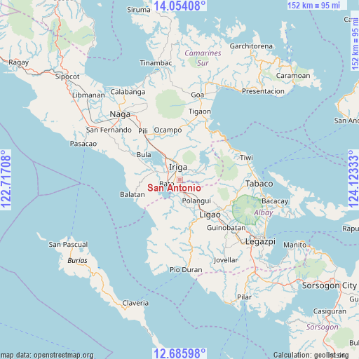
San Antonio GPS coordinates[2]
13° 22' 15.6" North, 123° 25' 12.72" East
| Map corner | latitude | longitude |
|---|---|---|
| Upper-left | 14.05408°, | 122.71708° |
| Center: | 13.371°, | 123.4202° |
| Lower-right: | 12.68598°, | 124.12333° |
| Map W x H: | 152.1×152.1 km | = 94.5×94.5mi |
| max Lat: | 20.78733° ⇑39.1% North |
| San Antonio: | 13.371° |
| min Lat: | ⇓60.9% South 4.65442° |
| min Long | San Antonio | max Long |
| 117.04868° | 123.4202° | 126.58417° |
| W 60.8%⇐ | ⇒39.2% E |
Elevation
Elevation of San Antonio is 42 m = 138 ft, and this is 45.9 m = 151 ft below average elevation for this country.
| Max E: |
2262 m = 7421 ft | 34.8% |
| Avg. | 87.9 m = 288 ft | |
| San Antonio | 42 m = 138 ft | |
Min E: |
-2 m = -7 ft | 65.2% |
See also: Philippines elevation on elevation.city.
Geographical zone
San Antonio is located in North Torrid zone (between Equator and Tropic of Cancer). Distance of this Northern Tropic circle is 1119.2 km =695.4 mi to North.| Distance of | km | miles | from San Antonio |
|---|---|---|---|
| North Pole | 8520.3 | 5294.3 | to North |
| Arctic Circle | 5914.5 | 3675.1 | to North |
| Tropic Cancer | 1119.2 | 695.4 | to North |
| Equator | 1486.7 | 923.8 | to South |


Nearby cities:
15 places around San Antonio: (largest is in red/bold)
• Agos
3.9 km =2.4 mi,  217°
217°
• Bato
6 km =3.7 mi,  250°
250°
• Iriga City
6.9 km =4.3 mi,  352°
352°
• Lanigay
10.5 km =6.5 mi,  124°
124°
• Libon
8.2 km =5.1 mi,  165°
165°
• Lourdes
5.5 km =3.4 mi,  292°
292°
• Masoli
3.5 km =2.2 mi, 248°
• Matacon
5 km =3.1 mi,  160°
160°
• Nabua
6.6 km =4.1 mi,  308°
308°
• San Agustin
5 km =3.1 mi,  183°
183°
• San Miguel
5.6 km =3.5 mi, 346°
• San Vicente
4.1 km =2.5 mi,  357°
357°
• San Vicente
10.4 km =6.5 mi,  330°
330°
• Santa Justina
6.4 km =4 mi,  63°
63°
• Santo Domingo
6.3 km =3.9 mi,  29°
29°
Sources, notices
• [Note1] Compared only with cities in Philippines existing in our database
• [Src1] Map data: © OpenStreetMap contributors (CC-BY-SA)
• [Src2] Other city data from geonames.org with taken over terms of usage.
• [Src3] Geographical zone / Annual Mean Temperature by Robert A. Rohde @ Wikipedia
