Nabua geodata
Nabua (Bicol) is a seat of a third-order administrative division; located in Philippines in Asia/Manila (GMT+8) time zone. With population of 25,687 people, there are 317 cities with bigger population in this country. Compared to other cities in Philippines, 61.2% of cities are located further ↓South; 59.7% of cities are located further ←West and 67.4% of cities have higher elevation than Nabua. Note1


Nabua GPS coordinates[2]
13° 24' 27" North, 123° 22' 20.64" East
| Map corner | latitude | longitude |
|---|---|---|
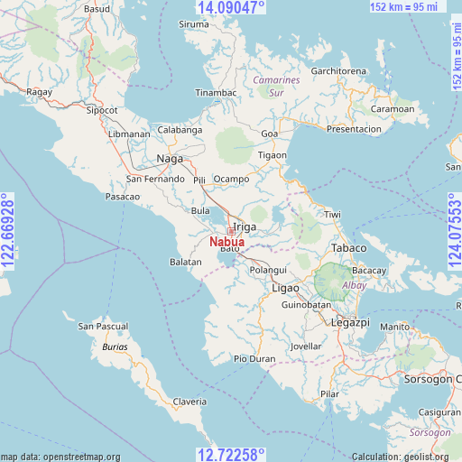
| Upper-left | 14.09047°, | 122.66928° |
| Center: | 13.4075°, | 123.3724° |
| Lower-right: | 12.72258°, | 124.07553° |
| Map W x H: | 152.1×152.1 km | = 94.5×94.5mi |
| max Lat: | 20.78733° ⇑38.8% North |
| Nabua: | 13.4075° |
| min Lat: | ⇓61.2% South 4.65442° |
| min Long | Nabua | max Long |
| 117.04868° | 123.3724° | 126.58417° |
| W 59.7%⇐ | ⇒40.3% E |
Elevation
Elevation of Nabua is 13 m = 43 ft, and this is 74.9 m = 246 ft below average elevation for this country.
| Max E: |
2262 m = 7421 ft | 67.4% |
| Avg. | 87.9 m = 288 ft | |
| Nabua | 13 m = 43 ft | |
Min E: |
-2 m = -7 ft | 32.6% |
See also: Philippines elevation on elevation.city.
Geographical zone
Nabua is located in North Torrid zone (between Equator and Tropic of Cancer). Distance of this Northern Tropic circle is 1115.1 km =692.9 mi to North.| Distance of | km | miles | from Nabua |
|---|---|---|---|
| North Pole | 8516.3 | 5291.8 | to North |
| Arctic Circle | 5910.4 | 3672.6 | to North |
| Tropic Cancer | 1115.1 | 692.9 | to North |
| Equator | 1490.8 | 926.3 | to South |


Nearby cities:
15 places around Nabua: (largest is in red/bold)
• Agos
7.7 km =4.8 mi,  158°
158°
• Agupit
5.4 km =3.4 mi,  287°
287°
• Baao
5.3 km =3.3 mi,  351°
351°
• Bagumbayan
6.7 km =4.2 mi,  16°
16°
• Bato
6.1 km =3.8 mi,  184°
184°
• Inapatan
5.5 km =3.4 mi,  257°
257°
• Iriga City
5.1 km =3.2 mi,  56°
56°
• Lourdes
2 km =1.2 mi, 176°
• Masoli
5.7 km =3.5 mi, 160°
• Salvacion
6.2 km =3.9 mi,  4°
4°
• San Antonio
6.6 km =4.1 mi,  128°
128°
• San Miguel
4.1 km =2.5 mi,  70°
70°
• San Vicente
5 km =3.1 mi, 0°
• San Vicente
5 km =3.1 mi,  89°
89°
• Santo Domingo
8.4 km =5.2 mi,  80°
80°
Sources, notices
• [Note1] Compared only with cities in Philippines existing in our database
• [Src1] Map data: © OpenStreetMap contributors (CC-BY-SA)
• [Src2] Other city data from geonames.org with taken over terms of usage.
• [Src3] Geographical zone / Annual Mean Temperature by Robert A. Rohde @ Wikipedia
