Santol geodata
Santol (Ilocos) is a seat of a third-order administrative division; located in Philippines in Asia/Manila (GMT+8) time zone. In our database, there are 4166 cities with bigger population. Compared to other cities in Philippines, 92.1% of cities are located further ↓South; 91.8% of cities are located further →East and 76.6% of cities have lower elevation than Santol. Note1


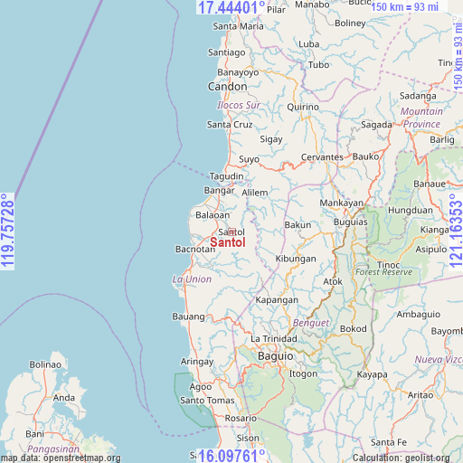
Santol GPS coordinates[2]
16° 46' 19.2" North, 120° 27' 37.44" East
| Map corner | latitude | longitude |
|---|---|---|
| Upper-left | 17.44401°, | 119.75728° |
| Center: | 16.772°, | 120.4604° |
| Lower-right: | 16.09761°, | 121.16353° |
| Map W x H: | 149.7×149.7 km | = 93×93mi |
| max Lat: | 20.78733° ⇑7.9% North |
| Santol: | 16.772° |
| min Lat: | ⇓92.1% South 4.65442° |
| min Long | Santol | max Long |
| 117.04868° | 120.4604° | 126.58417° |
| W 8.2%⇐ | ⇒91.8% E |
Elevation
Elevation of Santol is 74 m = 243 ft, and this is 13.9 m = 46 ft below average elevation for this country.
| Max E: |
2262 m = 7421 ft | 23.4% |
| Avg. | 87.9 m = 288 ft | |
| Santol | 74 m = 243 ft | |
Min E: |
-2 m = -7 ft | 76.6% |
See also: Philippines elevation on elevation.city.
Geographical zone
Santol is located in North Torrid zone (between Equator and Tropic of Cancer). Distance of this Northern Tropic circle is 741 km =460.4 mi to North.| Distance of | km | miles | from Santol |
|---|---|---|---|
| North Pole | 8142.2 | 5059.3 | to North |
| Arctic Circle | 5536.3 | 3440.1 | to North |
| Tropic Cancer | 741 | 460.4 | to North |
| Equator | 1864.9 | 1158.8 | to South |


Nearby cities:
15 places around Santol: (largest is in red/bold)
• Alilem
14.7 km =9.1 mi,  30°
30°
• Bacnotan
12.8 km =8 mi,  244°
244°
• Balaoan
8.1 km =5 mi,  312°
312°
• Bangar
14.1 km =8.8 mi,  344°
344°
• Butubut Norte
4.5 km =2.8 mi,  321°
321°
• Cantoria
10 km =6.2 mi, 323°
• Corrooy
3.1 km =1.9 mi,  329°
329°
• Luna
12.7 km =7.9 mi, 315°
• Lusong
10.7 km =6.6 mi,  349°
349°
• Oaqui
10.9 km =6.8 mi, 331°
• Rimus
13.4 km =8.3 mi, 329°
• Rissing
11.8 km =7.3 mi, 346°
• San Gabriel
12.3 km =7.6 mi,  209°
209°
• Sudipen
14.9 km =9.3 mi,  0°
0°
• Sugpon
9.9 km =6.2 mi,  36°
36°
Sources, notices
• [Note1] Compared only with cities in Philippines existing in our database
• [Src1] Map data: © OpenStreetMap contributors (CC-BY-SA)
• [Src2] Other city data from geonames.org with taken over terms of usage.
• [Src3] Geographical zone / Annual Mean Temperature by Robert A. Rohde @ Wikipedia
