Balaoan geodata
Balaoan (Ilocos) is a seat of a third-order administrative division; located in Philippines in Asia/Manila (GMT+8) time zone. With population of 2,928 people, there are 2614 cities with bigger population in this country. Compared to other cities in Philippines, 92.4% of cities are located further ↓South; 93.6% of cities are located further →East and 65.1% of cities have higher elevation than Balaoan. Note1


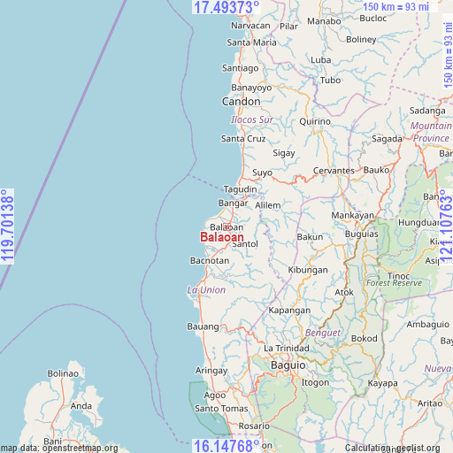
Balaoan GPS coordinates[2]
16° 49' 18.84" North, 120° 24' 16.2" East
| Map corner | latitude | longitude |
|---|---|---|
| Upper-left | 17.49373°, | 119.70138° |
| Center: | 16.8219°, | 120.4045° |
| Lower-right: | 16.14768°, | 121.10763° |
| Map W x H: | 149.7×149.7 km | = 93×93mi |
| max Lat: | 20.78733° ⇑7.6% North |
| Balaoan: | 16.8219° |
| min Lat: | ⇓92.4% South 4.65442° |
| min Long | Balaoan | max Long |
| 117.04868° | 120.4045° | 126.58417° |
| W 6.4%⇐ | ⇒93.6% E |
Elevation
Elevation of Balaoan is 14 m = 46 ft, and this is 73.9 m = 242 ft below average elevation for this country.
| Max E: |
2262 m = 7421 ft | 65.1% |
| Avg. | 87.9 m = 288 ft | |
| Balaoan | 14 m = 46 ft | |
Min E: |
-2 m = -7 ft | 34.9% |
See also: Philippines elevation on elevation.city.
Geographical zone
Balaoan is located in North Torrid zone (between Equator and Tropic of Cancer). Distance of this Northern Tropic circle is 735.5 km =457 mi to North.| Distance of | km | miles | from Balaoan |
|---|---|---|---|
| North Pole | 8136.6 | 5055.8 | to North |
| Arctic Circle | 5530.8 | 3436.7 | to North |
| Tropic Cancer | 735.5 | 457 | to North |
| Equator | 1870.4 | 1162.2 | to South |


Nearby cities:
15 places around Balaoan: (largest is in red/bold)
• Bacnotan
12.4 km =7.7 mi,  206°
206°
• Bangar
8.2 km =5.1 mi,  14°
14°
• Butubut Norte
3.8 km =2.4 mi,  122°
122°
• Cantoria
2.5 km =1.6 mi,  0°
0°
• Corrooy
5.2 km =3.2 mi, 123°
• Luna
4.6 km =2.9 mi,  318°
318°
• Lusong
6.4 km =4 mi,  38°
38°
• Oaqui
4.1 km =2.5 mi, 11°
• Pudoc
11.3 km =7 mi, 10°
• Rimus
6.1 km =3.8 mi,  352°
352°
• Rissing
6.7 km =4.2 mi,  28°
28°
• Santol
8.1 km =5 mi,  132°
132°
• Sudipen
11.1 km =6.9 mi, 33°
• Sugpon
12.1 km =7.5 mi,  78°
78°
• Tagudin
13.3 km =8.3 mi,  18°
18°
Sources, notices
• [Note1] Compared only with cities in Philippines existing in our database
• [Src1] Map data: © OpenStreetMap contributors (CC-BY-SA)
• [Src2] Other city data from geonames.org with taken over terms of usage.
• [Src3] Geographical zone / Annual Mean Temperature by Robert A. Rohde @ Wikipedia
