Bacnotan geodata
Bacnotan (Ilocos) is a seat of a third-order administrative division; located in Philippines in Asia/Manila (GMT+8) time zone. With population of 3,142 people, there are 2368 cities with bigger population in this country. Compared to other cities in Philippines, 91.9% of cities are located further ↓South; 94.7% of cities are located further →East and 73.2% of cities have higher elevation than Bacnotan. Note1


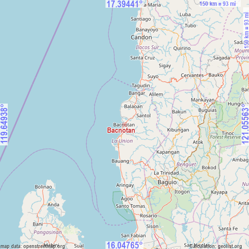
Bacnotan GPS coordinates[2]
16° 43' 19.992" North, 120° 21' 9" East
| Map corner | latitude | longitude |
|---|---|---|
| Upper-left | 17.39441°, | 119.64938° |
| Center: | 16.72222°, | 120.3525° |
| Lower-right: | 16.04765°, | 121.05563° |
| Map W x H: | 149.7×149.7 km | = 93×93mi |
| max Lat: | 20.78733° ⇑8.1% North |
| Bacnotan: | 16.72222° |
| min Lat: | ⇓91.9% South 4.65442° |
| min Long | Bacnotan | max Long |
| 117.04868° | 120.3525° | 126.58417° |
| W 5.3%⇐ | ⇒94.7% E |
Elevation
Elevation of Bacnotan is 11 m = 36 ft, and this is 76.9 m = 252 ft below average elevation for this country.
| Max E: |
2262 m = 7421 ft | 73.2% |
| Avg. | 87.9 m = 288 ft | |
| Bacnotan | 11 m = 36 ft | |
Min E: |
-2 m = -7 ft | 26.8% |
See also: Philippines elevation on elevation.city.
Geographical zone
Bacnotan is located in North Torrid zone (between Equator and Tropic of Cancer). Distance of this Northern Tropic circle is 746.6 km =463.9 mi to North.| Distance of | km | miles | from Bacnotan |
|---|---|---|---|
| North Pole | 8147.7 | 5062.7 | to North |
| Arctic Circle | 5541.8 | 3443.5 | to North |
| Tropic Cancer | 746.6 | 463.9 | to North |
| Equator | 1859.3 | 1155.3 | to South |


Nearby cities:
15 places around Bacnotan: (largest is in red/bold)
• Bagulin
15.7 km =9.8 mi,  143°
143°
• Balaoan
12.4 km =7.7 mi,  26°
26°
• Butubut Norte
12.6 km =7.8 mi,  44°
44°
• Cantoria
14.6 km =9.1 mi,  22°
22°
• Corrooy
12.9 km =8 mi,  50°
50°
• Dagup
13.7 km =8.5 mi,  133°
133°
• Luna
14.7 km =9.1 mi,  9°
9°
• Lusong
18.7 km =11.6 mi, 30°
• Oaqui
16.4 km =10.2 mi, 22°
• Paringao
17 km =10.6 mi,  190°
190°
• Rimus
17.8 km =11.1 mi, 15°
• San Fernando
12.4 km =7.7 mi,  197°
197°
• San Gabriel
7.5 km =4.7 mi, 133°
• San Juan
6.1 km =3.8 mi, 191°
• Santol
12.8 km =8 mi,  64°
64°
Sources, notices
• [Note1] Compared only with cities in Philippines existing in our database
• [Src1] Map data: © OpenStreetMap contributors (CC-BY-SA)
• [Src2] Other city data from geonames.org with taken over terms of usage.
• [Src3] Geographical zone / Annual Mean Temperature by Robert A. Rohde @ Wikipedia
