Santa Maria geodata
Santa Maria (Ilocos) is a seat of a third-order administrative division; located in Philippines in Asia/Manila (GMT+8) time zone. In our database, there are 4166 cities with bigger population. Compared to other cities in Philippines, 87.2% of cities are located further ↓South; 84.9% of cities are located further →East and 67.1% of cities have lower elevation than Santa Maria. Note1


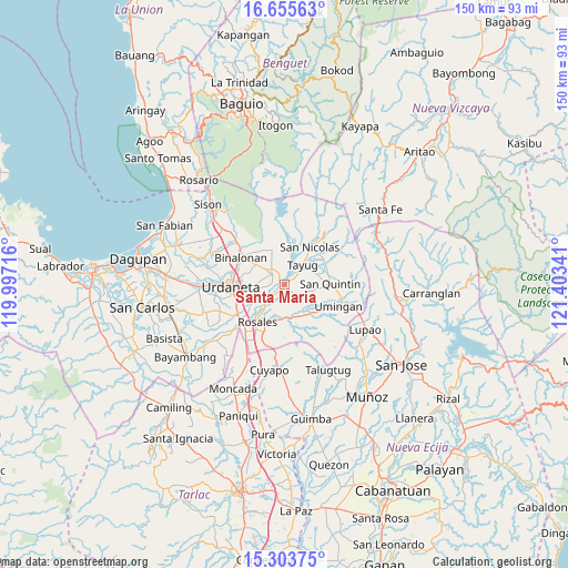
Santa Maria GPS coordinates[2]
15° 58' 50.988" North, 120° 42' 1.008" East
| Map corner | latitude | longitude |
|---|---|---|
| Upper-left | 16.65563°, | 119.99716° |
| Center: | 15.98083°, | 120.70028° |
| Lower-right: | 15.30375°, | 121.40341° |
| Map W x H: | 150.3×150.3 km | = 93.4×93.4mi |
| max Lat: | 20.78733° ⇑12.8% North |
| Santa Maria: | 15.98083° |
| min Lat: | ⇓87.2% South 4.65442° |
| min Long | Santa Maria | max Long |
| 117.04868° | 120.70028° | 126.58417° |
| W 15.1%⇐ | ⇒84.9% E |
Elevation
Elevation of Santa Maria is 46 m = 151 ft, and this is 41.9 m = 137 ft below average elevation for this country.
| Max E: |
2262 m = 7421 ft | 32.9% |
| Avg. | 87.9 m = 288 ft | |
| Santa Maria | 46 m = 151 ft | |
Min E: |
-2 m = -7 ft | 67.1% |
See also: Philippines elevation on elevation.city.
Geographical zone
Santa Maria is located in North Torrid zone (between Equator and Tropic of Cancer). Distance of this Northern Tropic circle is 829 km =515.1 mi to North.| Distance of | km | miles | from Santa Maria |
|---|---|---|---|
| North Pole | 8230.2 | 5114 | to North |
| Arctic Circle | 5624.3 | 3494.8 | to North |
| Tropic Cancer | 829 | 515.1 | to North |
| Equator | 1776.9 | 1104.1 | to South |


Nearby cities:
15 places around Santa Maria: (largest is in red/bold)
• Asingan
4.3 km =2.7 mi,  309°
309°
• Bantog
3.2 km =2 mi,  345°
345°
• Baro
3.5 km =2.2 mi, 305°
• Cabalaoangan
8.9 km =5.5 mi,  88°
88°
• Capandanan
2.4 km =1.5 mi,  192°
192°
• Carriedo
8.1 km =5 mi,  46°
46°
• Carusucan
7.1 km =4.4 mi,  256°
256°
• Domampot
5.8 km =3.6 mi,  291°
291°
• Gueset
7.9 km =4.9 mi,  244°
244°
• Macalong
5.8 km =3.6 mi, 309°
• Magallanes
6 km =3.7 mi,  43°
43°
• Panganiban
8.5 km =5.3 mi,  69°
69°
• Samon
7.4 km =4.6 mi,  226°
226°
• Tayug
6.9 km =4.3 mi, 41°
• Toboy
8.5 km =5.3 mi, 307°
Sources, notices
• [Note1] Compared only with cities in Philippines existing in our database
• [Src1] Map data: © OpenStreetMap contributors (CC-BY-SA)
• [Src2] Other city data from geonames.org with taken over terms of usage.
• [Src3] Geographical zone / Annual Mean Temperature by Robert A. Rohde @ Wikipedia
