Santa Fe geodata
Santa Fe (Mimaropa) is a seat of a third-order administrative division; located in Philippines in Asia/Manila (GMT+8) time zone. With population of 2,358 people, there are 3542 cities with bigger population in this country. Compared to other cities in Philippines, 52.5% of cities are located further ↓South; 60.3% of cities are located further →East and 67.4% of cities have higher elevation than Santa Fe. Note1


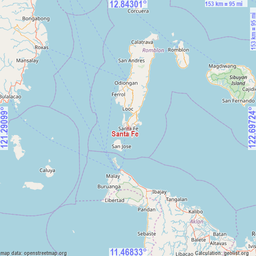
Santa Fe GPS coordinates[2]
12° 9' 23.616" North, 121° 59' 38.796" East
| Map corner | latitude | longitude |
|---|---|---|
| Upper-left | 12.84301°, | 121.29099° |
| Center: | 12.15656°, | 121.99411° |
| Lower-right: | 11.46833°, | 122.69724° |
| Map W x H: | 152.9×152.9 km | = 95×95mi |
| max Lat: | 20.78733° ⇑47.5% North |
| Santa Fe: | 12.15656° |
| min Lat: | ⇓52.5% South 4.65442° |
| min Long | Santa Fe | max Long |
| 117.04868° | 121.99411° | 126.58417° |
| W 39.7%⇐ | ⇒60.3% E |
Elevation
Elevation of Santa Fe is 13 m = 43 ft, and this is 74.9 m = 246 ft below average elevation for this country.
| Max E: |
2262 m = 7421 ft | 67.4% |
| Avg. | 87.9 m = 288 ft | |
| Santa Fe | 13 m = 43 ft | |
Min E: |
-2 m = -7 ft | 32.6% |
See also: Philippines elevation on elevation.city.
Geographical zone
Santa Fe is located in North Torrid zone (between Equator and Tropic of Cancer). Distance of this Northern Tropic circle is 1254.2 km =779.3 mi to North.| Distance of | km | miles | from Santa Fe |
|---|---|---|---|
| North Pole | 8655.4 | 5378.2 | to North |
| Arctic Circle | 6049.5 | 3759 | to North |
| Tropic Cancer | 1254.2 | 779.3 | to North |
| Equator | 1351.7 | 839.9 | to South |


Nearby cities:
15 places around Santa Fe: (largest is in red/bold)
• Agcogon
11.2 km =7 mi,  199°
199°
• Alcantara
13.1 km =8.1 mi,  29°
29°
• Balabag
22.3 km =13.9 mi, 201°
• Caticlan
25.1 km =15.6 mi,  188°
188°
• Ferrol
21 km =13 mi,  344°
344°
• Lanas
14.5 km =9 mi,  214°
214°
• Limon
16.1 km =10 mi,  8°
8°
• Looc
11.6 km =7.2 mi,  359°
359°
• Malabonot
22.4 km =13.9 mi, 200°
• Manoc-Manoc
24.5 km =15.2 mi, 193°
• Odiongan
27.3 km =17 mi, 359°
• Punta
9.9 km =6.2 mi, 9°
• Tugdan
20.1 km =12.5 mi, 29°
• Unidos
27.8 km =17.3 mi,  178°
178°
• Yapak
23.9 km =14.9 mi, 196°
Sources, notices
• [Note1] Compared only with cities in Philippines existing in our database
• [Src1] Map data: © OpenStreetMap contributors (CC-BY-SA)
• [Src2] Other city data from geonames.org with taken over terms of usage.
• [Src3] Geographical zone / Annual Mean Temperature by Robert A. Rohde @ Wikipedia
