Santa geodata
Santa (Ilocos) is a seat of a third-order administrative division; located in Philippines in Asia/Manila (GMT+8) time zone. With population of 2,283 people, there are 3716 cities with bigger population in this country. Compared to other cities in Philippines, 96.1% of cities are located further ↓South; 92.7% of cities are located further →East and 67.4% of cities have higher elevation than Santa. Note1


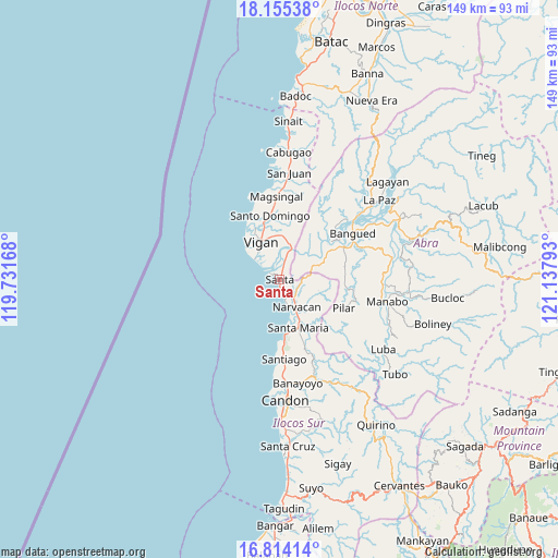
Santa GPS coordinates[2]
17° 29' 9.6" North, 120° 26' 5.28" East
| Map corner | latitude | longitude |
|---|---|---|
| Upper-left | 18.15538°, | 119.73168° |
| Center: | 17.486°, | 120.4348° |
| Lower-right: | 16.81414°, | 121.13793° |
| Map W x H: | 149.1×149.1 km | = 92.6×92.6mi |
| max Lat: | 20.78733° ⇑3.9% North |
| Santa: | 17.486° |
| min Lat: | ⇓96.1% South 4.65442° |
| min Long | Santa | max Long |
| 117.04868° | 120.4348° | 126.58417° |
| W 7.3%⇐ | ⇒92.7% E |
Elevation
Elevation of Santa is 13 m = 43 ft, and this is 74.9 m = 246 ft below average elevation for this country.
| Max E: |
2262 m = 7421 ft | 67.4% |
| Avg. | 87.9 m = 288 ft | |
| Santa | 13 m = 43 ft | |
Min E: |
-2 m = -7 ft | 32.6% |
See also: Philippines elevation on elevation.city.
Geographical zone
Santa is located in North Torrid zone (between Equator and Tropic of Cancer). Distance of this Northern Tropic circle is 661.7 km =411.2 mi to North.| Distance of | km | miles | from Santa |
|---|---|---|---|
| North Pole | 8062.8 | 5010 | to North |
| Arctic Circle | 5456.9 | 3390.8 | to North |
| Tropic Cancer | 661.7 | 411.2 | to North |
| Equator | 1944.3 | 1208.1 | to South |


Nearby cities:
15 places around Santa: (largest is in red/bold)
• Bantay
12 km =7.5 mi,  336°
336°
• Cabittaogan
13 km =8.1 mi,  321°
321°
• Caoayan
9.3 km =5.8 mi,  334°
334°
• Fuerte
8.8 km =5.5 mi,  307°
307°
• Lungog
5.2 km =3.2 mi,  117°
117°
• Mabilbila Sur
2.4 km =1.5 mi,  15°
15°
• Nagbukel
10.5 km =6.5 mi,  114°
114°
• Narvacan
8.7 km =5.4 mi,  150°
150°
• Quinarayan
6.1 km =3.8 mi,  139°
139°
• San Quintin
11 km =6.8 mi,  55°
55°
• San Vicente
13.9 km =8.6 mi, 332°
• Santa Catalina
14.7 km =9.1 mi, 326°
• Santa Maria
14.2 km =8.8 mi,  159°
159°
• Suso
14.4 km =8.9 mi,  168°
168°
• Vigan
11.1 km =6.9 mi, 332°
Sources, notices
• [Note1] Compared only with cities in Philippines existing in our database
• [Src1] Map data: © OpenStreetMap contributors (CC-BY-SA)
• [Src2] Other city data from geonames.org with taken over terms of usage.
• [Src3] Geographical zone / Annual Mean Temperature by Robert A. Rohde @ Wikipedia
