San Pedro geodata
San Pedro (Mimaropa) is a populated place; located in Philippines in Asia/Manila (GMT+8) time zone. With population of 2,698 people, there are 2949 cities with bigger population in this country. Compared to other cities in Philippines, 54.6% of cities are located further ↓South; 76.1% of cities are located further →East and 60.8% of cities have higher elevation than San Pedro. Note1
Administrative division(s):
- Level 1: Mimaropa
- Level 2: Province of Mindoro Occidental
- Level 3: Rizal


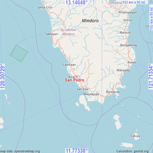
San Pedro GPS coordinates[2]
12° 27' 39.024" North, 121° 0' 37.476" East
| Map corner | latitude | longitude |
|---|---|---|
| Upper-left | 13.14648°, | 120.30729° |
| Center: | 12.46084°, | 121.01041° |
| Lower-right: | 11.77338°, | 121.71354° |
| Map W x H: | 152.7×152.7 km | = 94.9×94.9mi |
| max Lat: | 20.78733° ⇑45.4% North |
| San Pedro: | 12.46084° |
| min Lat: | ⇓54.6% South 4.65442° |
| min Long | San Pedro | max Long |
| 117.04868° | 121.01041° | 126.58417° |
| W 23.9%⇐ | ⇒76.1% E |
Elevation
Elevation of San Pedro is 16 m = 52 ft, and this is 71.9 m = 236 ft below average elevation for this country.
| Max E: |
2262 m = 7421 ft | 60.8% |
| Avg. | 87.9 m = 288 ft | |
| San Pedro | 16 m = 52 ft | |
Min E: |
-2 m = -7 ft | 39.2% |
See also: Philippines elevation on elevation.city.
Geographical zone
San Pedro is located in North Torrid zone (between Equator and Tropic of Cancer). Distance of this Northern Tropic circle is 1220.4 km =758.3 mi to North.| Distance of | km | miles | from San Pedro |
|---|---|---|---|
| North Pole | 8621.5 | 5357.2 | to North |
| Arctic Circle | 6015.7 | 3738 | to North |
| Tropic Cancer | 1220.4 | 758.3 | to North |
| Equator | 1385.5 | 860.9 | to South |


Nearby cities:
15 places around San Pedro: (largest is in red/bold)
• Adela
4.6 km =2.9 mi,  242°
242°
• Babug
10.3 km =6.4 mi,  160°
160°
• Bagong Sikat
11.8 km =7.3 mi,  151°
151°
• Calintaan
14.4 km =8.9 mi,  324°
324°
• Caminauit
16.4 km =10.2 mi, 151°
• Irirum
19.3 km =12 mi,  333°
333°
• La Curva
7.3 km =4.5 mi, 148°
• Magbay
10.3 km =6.4 mi,  123°
123°
• Magsaysay
20.8 km =12.9 mi,  133°
133°
• Mangarine
15.5 km =9.6 mi,  142°
142°
• Paclolo
20 km =12.4 mi, 117°
• Pitogo
10.1 km =6.3 mi,  59°
59°
• Rizal
4.8 km =3 mi,  277°
277°
• San Agustin
5.1 km =3.2 mi,  206°
206°
• San Jose
13.5 km =8.4 mi, 152°
Sources, notices
• [Note1] Compared only with cities in Philippines existing in our database
• [Src1] Map data: © OpenStreetMap contributors (CC-BY-SA)
• [Src2] Other city data from geonames.org with taken over terms of usage.
• [Src3] Geographical zone / Annual Mean Temperature by Robert A. Rohde @ Wikipedia
