Calintaan geodata
Calintaan (Mimaropa) is a populated place; located in Philippines in Asia/Manila (GMT+8) time zone. With population of 11,476 people, there are 536 cities with bigger population in this country. Compared to other cities in Philippines, 55.2% of cities are located further ↓South; 78.4% of cities are located further →East and 99.6% of cities have higher elevation than Calintaan. Note1


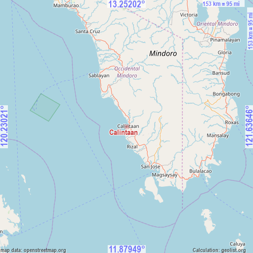
Calintaan GPS coordinates[2]
12° 34' 0.012" North, 120° 55' 59.988" East
| Map corner | latitude | longitude |
|---|---|---|
| Upper-left | 13.25202°, | 120.23021° |
| Center: | 12.56667°, | 120.93333° |
| Lower-right: | 11.87949°, | 121.63646° |
| Map W x H: | 152.6×152.6 km | = 94.8×94.8mi |
| max Lat: | 20.78733° ⇑44.8% North |
| Calintaan: | 12.56667° |
| min Lat: | ⇓55.2% South 4.65442° |
| min Long | Calintaan | max Long |
| 117.04868° | 120.93333° | 126.58417° |
| W 21.6%⇐ | ⇒78.4% E |
Elevation
Elevation of Calintaan is 1 m = 3 ft, and this is 86.9 m = 285 ft below average elevation for this country.
| Max E: |
2262 m = 7421 ft | 99.6% |
| Avg. | 87.9 m = 288 ft | |
| Calintaan | 1 m = 3 ft | |
Min E: |
-2 m = -7 ft | 0.4% |
See also: Philippines elevation on elevation.city.
Geographical zone
Calintaan is located in North Torrid zone (between Equator and Tropic of Cancer). Distance of this Northern Tropic circle is 1208.6 km =751 mi to North.| Distance of | km | miles | from Calintaan |
|---|---|---|---|
| North Pole | 8609.8 | 5349.9 | to North |
| Arctic Circle | 6003.9 | 3730.6 | to North |
| Tropic Cancer | 1208.6 | 751 | to North |
| Equator | 1397.3 | 868.2 | to South |


Nearby cities:
15 places around Calintaan: (largest is in red/bold)
• Adela
14.6 km =9.1 mi,  162°
162°
• Babug
24.5 km =15.2 mi,  151°
151°
• Bagong Sikat
26.2 km =16.3 mi, 147°
• Banos
9.1 km =5.7 mi,  343°
343°
• Batasan
27.6 km =17.1 mi,  323°
323°
• Irirum
5.5 km =3.4 mi,  356°
356°
• La Curva
21.8 km =13.5 mi, 145°
• Ligaya
11.3 km =7 mi, 336°
• Magbay
24.3 km =15.1 mi,  135°
135°
• Pitogo
18.3 km =11.4 mi,  111°
111°
• Rizal
11.7 km =7.3 mi, 161°
• San Agustin
17.4 km =10.8 mi, 159°
• San Jose
27.9 km =17.3 mi, 148°
• San Pedro
14.4 km =8.9 mi, 144°
• Tuban
29.4 km =18.3 mi, 338°
Sources, notices
• [Note1] Compared only with cities in Philippines existing in our database
• [Src1] Map data: © OpenStreetMap contributors (CC-BY-SA)
• [Src2] Other city data from geonames.org with taken over terms of usage.
• [Src3] Geographical zone / Annual Mean Temperature by Robert A. Rohde @ Wikipedia
