San Miguel geodata
San Miguel (Central Visayas) is a populated place; located in Philippines in Asia/Manila (GMT+8) time zone. With population of 2,769 people, there are 2844 cities with bigger population in this country. Compared to other cities in Philippines, 74.5% of cities are located further ↑North; 58% of cities are located further ←West and 57.6% of cities have higher elevation than San Miguel. Note1
Administrative division(s):
- Level 1: Central Visayas
- Level 2: Province of Negros Oriental
- Level 3: Bacong


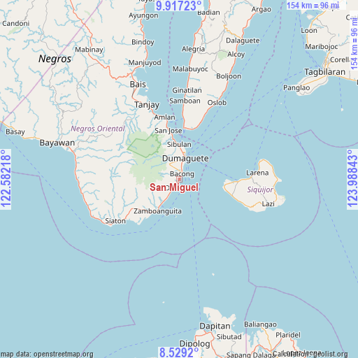
San Miguel GPS coordinates[2]
9° 13' 26.04" North, 123° 17' 7.08" East
| Map corner | latitude | longitude |
|---|---|---|
| Upper-left | 9.91723°, | 122.58218° |
| Center: | 9.2239°, | 123.2853° |
| Lower-right: | 8.5292°, | 123.98843° |
| Map W x H: | 154.3×154.3 km | = 95.9×95.9mi |
| max Lat: | 20.78733° ⇑74.5% North |
| San Miguel: | 9.2239° |
| min Lat: | ⇓25.5% South 4.65442° |
| min Long | San Miguel | max Long |
| 117.04868° | 123.2853° | 126.58417° |
| W 58%⇐ | ⇒42% E |
Elevation
Elevation of San Miguel is 18 m = 59 ft, and this is 69.9 m = 229 ft below average elevation for this country.
| Max E: |
2262 m = 7421 ft | 57.6% |
| Avg. | 87.9 m = 288 ft | |
| San Miguel | 18 m = 59 ft | |
Min E: |
-2 m = -7 ft | 42.4% |
See also: Philippines elevation on elevation.city.
Geographical zone
San Miguel is located in North Torrid zone (between Equator and Tropic of Cancer). Distance of Equator is 1025.6 km =637.3 mi to South.| Distance of | km | miles | from San Miguel |
|---|---|---|---|
| North Pole | 8981.5 | 5580.8 | to North |
| Arctic Circle | 6375.6 | 3961.6 | to North |
| Tropic Cancer | 1580.3 | 982 | to North |
| Equator | 1025.6 | 637.3 | to South |


Nearby cities:
15 places around San Miguel: (largest is in red/bold)
• Bacong
2.7 km =1.7 mi,  24°
24°
• Banilad
6.1 km =3.8 mi,  8°
8°
• Dauin
4.2 km =2.6 mi,  211°
211°
• Dumaguete
9.5 km =5.9 mi, 11°
• Maayong Tubig
7.6 km =4.7 mi, 213°
• Mainit
24.7 km =15.3 mi, 19°
• Malway
12.5 km =7.8 mi, 214°
• Mayabon
18.8 km =11.7 mi,  220°
220°
• San Jose
21.5 km =13.4 mi,  346°
346°
• San Juan
23.8 km =14.8 mi,  107°
107°
• Santander Poblacion
23.1 km =14.4 mi, 14°
• Sibulan
15 km =9.3 mi,  359°
359°
• Siquijor
25.2 km =15.7 mi,  92°
92°
• Valencia
7.8 km =4.8 mi,  325°
325°
• Zamboanguita
16.5 km =10.3 mi, 214°
Sources, notices
• [Note1] Compared only with cities in Philippines existing in our database
• [Src1] Map data: © OpenStreetMap contributors (CC-BY-SA)
• [Src2] Other city data from geonames.org with taken over terms of usage.
• [Src3] Geographical zone / Annual Mean Temperature by Robert A. Rohde @ Wikipedia
