San Juan geodata
San Juan (Central Visayas) is a seat of a third-order administrative division; located in Philippines in Asia/Manila (GMT+8) time zone. In our database, there are 4166 cities with bigger population. Compared to other cities in Philippines, 74.8% of cities are located further ↑North; 62% of cities are located further ←West and 62.8% of cities have higher elevation than San Juan. Note1
Administrative division(s):
- Level 1: Central Visayas
- Level 2: Province of Siquijor
- Level 3: San Juan


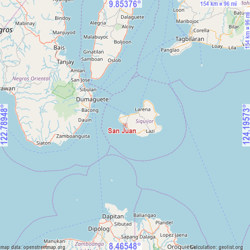
San Juan GPS coordinates[2]
9° 9' 37.08" North, 123° 29' 33.36" East
| Map corner | latitude | longitude |
|---|---|---|
| Upper-left | 9.85376°, | 122.78948° |
| Center: | 9.1603°, | 123.4926° |
| Lower-right: | 8.46548°, | 124.19573° |
| Map W x H: | 154.4×154.4 km | = 95.9×95.9mi |
| max Lat: | 20.78733° ⇑74.8% North |
| San Juan: | 9.1603° |
| min Lat: | ⇓25.2% South 4.65442° |
| min Long | San Juan | max Long |
| 117.04868° | 123.4926° | 126.58417° |
| W 62%⇐ | ⇒38% E |
Elevation
Elevation of San Juan is 15 m = 49 ft, and this is 72.9 m = 239 ft below average elevation for this country.
| Max E: |
2262 m = 7421 ft | 62.8% |
| Avg. | 87.9 m = 288 ft | |
| San Juan | 15 m = 49 ft | |
Min E: |
-2 m = -7 ft | 37.2% |
See also: Philippines elevation on elevation.city.
Geographical zone
San Juan is located in North Torrid zone (between Equator and Tropic of Cancer). Distance of Equator is 1018.5 km =632.9 mi to South.| Distance of | km | miles | from San Juan |
|---|---|---|---|
| North Pole | 8988.5 | 5585.2 | to North |
| Arctic Circle | 6382.6 | 3966 | to North |
| Tropic Cancer | 1587.4 | 986.4 | to North |
| Equator | 1018.5 | 632.9 | to South |


Nearby cities:
15 places around San Juan: (largest is in red/bold)
• Bacong
23.6 km =14.7 mi,  293°
293°
• Banilad
25.5 km =15.8 mi,  301°
301°
• Dauin
25.2 km =15.7 mi,  277°
277°
• Dumaguete
26.5 km =16.5 mi,  308°
308°
• Enrique Villanueva
21.3 km =13.2 mi,  52°
52°
• Larena
14.6 km =9.1 mi, 49°
• Lazi
16.1 km =10 mi,  102°
102°
• Maayong Tubig
27 km =16.8 mi,  271°
271°
• Malway
30.1 km =18.7 mi,  263°
263°
• Maria
18.3 km =11.4 mi,  76°
76°
• San Miguel
23.8 km =14.8 mi, 287°
• Sibulan
31.7 km =19.7 mi, 314°
• Siquijor
6.5 km =4 mi,  22°
22°
• Valencia
30.3 km =18.8 mi, 296°
• Zamboanguita
32.8 km =20.4 mi, 258°
Sources, notices
• [Note1] Compared only with cities in Philippines existing in our database
• [Src1] Map data: © OpenStreetMap contributors (CC-BY-SA)
• [Src2] Other city data from geonames.org with taken over terms of usage.
• [Src3] Geographical zone / Annual Mean Temperature by Robert A. Rohde @ Wikipedia
