San Jose geodata
San Jose (Central Visayas) is a seat of a third-order administrative division; located in Philippines in Asia/Manila (GMT+8) time zone. In our database, there are 4166 cities with bigger population. Compared to other cities in Philippines, 73.6% of cities are located further ↑North; 57.2% of cities are located further ←West and 60.9% of cities have lower elevation than San Jose. Note1
Administrative division(s):
- Level 1: Central Visayas
- Level 2: Province of Negros Oriental
- Level 3: San Jose


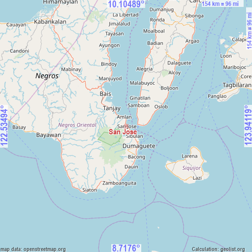
San Jose GPS coordinates[2]
9° 24' 42.984" North, 123° 14' 17.016" East
| Map corner | latitude | longitude |
|---|---|---|
| Upper-left | 10.10489°, | 122.53494° |
| Center: | 9.41194°, | 123.23806° |
| Lower-right: | 8.7176°, | 123.94119° |
| Map W x H: | 154.3×154.3 km | = 95.9×95.9mi |
| max Lat: | 20.78733° ⇑73.6% North |
| San Jose: | 9.41194° |
| min Lat: | ⇓26.4% South 4.65442° |
| min Long | San Jose | max Long |
| 117.04868° | 123.23806° | 126.58417° |
| W 57.2%⇐ | ⇒42.8% E |
Elevation
Elevation of San Jose is 35 m = 115 ft, and this is 52.9 m = 174 ft below average elevation for this country.
| Max E: |
2262 m = 7421 ft | 39.1% |
| Avg. | 87.9 m = 288 ft | |
| San Jose | 35 m = 115 ft | |
Min E: |
-2 m = -7 ft | 60.9% |
See also: Philippines elevation on elevation.city.
Geographical zone
San Jose is located in North Torrid zone (between Equator and Tropic of Cancer). Distance of Equator is 1046.5 km =650.3 mi to South.| Distance of | km | miles | from San Jose |
|---|---|---|---|
| North Pole | 8960.6 | 5567.9 | to North |
| Arctic Circle | 6354.7 | 3948.6 | to North |
| Tropic Cancer | 1559.4 | 969 | to North |
| Equator | 1046.5 | 650.3 | to South |


Nearby cities:
15 places around San Jose: (largest is in red/bold)
• Azagra
13.3 km =8.3 mi,  303°
303°
• Banilad
16 km =9.9 mi,  157°
157°
• Dumaguete
13.6 km =8.5 mi,  148°
148°
• Jantianon
8.7 km =5.4 mi,  294°
294°
• Jugno
7.3 km =4.5 mi,  329°
329°
• Mainit
13.5 km =8.4 mi,  79°
79°
• Pamplona
14.7 km =9.1 mi, 297°
• Polo
10 km =6.2 mi,  320°
320°
• Samboan
14.9 km =9.3 mi,  30°
30°
• Santander Poblacion
11.1 km =6.9 mi, 82°
• Sibulan
7.9 km =4.9 mi,  139°
139°
• Silab
7.1 km =4.4 mi, 294°
• Tandayag
4.8 km =3 mi,  349°
349°
• Tanjay
14.5 km =9 mi, 322°
• Valencia
14.5 km =9 mi,  176°
176°
Sources, notices
• [Note1] Compared only with cities in Philippines existing in our database
• [Src1] Map data: © OpenStreetMap contributors (CC-BY-SA)
• [Src2] Other city data from geonames.org with taken over terms of usage.
• [Src3] Geographical zone / Annual Mean Temperature by Robert A. Rohde @ Wikipedia
