San Lorenzo geodata
San Lorenzo (Central Luzon) is a populated place; located in Philippines in Asia/Manila (GMT+8) time zone. With population of 2,498 people, there are 3292 cities with bigger population in this country. Compared to other cities in Philippines, 81.6% of cities are located further ↓South; 97.3% of cities are located further →East and 60.8% of cities have higher elevation than San Lorenzo. Note1


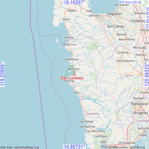
San Lorenzo GPS coordinates[2]
15° 29' 10.32" North, 119° 57' 43.92" East
| Map corner | latitude | longitude |
|---|---|---|
| Upper-left | 16.16267°, | 119.25908° |
| Center: | 15.4862°, | 119.9622° |
| Lower-right: | 14.80751°, | 120.66533° |
| Map W x H: | 150.7×150.7 km | = 93.6×93.6mi |
| max Lat: | 20.78733° ⇑18.4% North |
| San Lorenzo: | 15.4862° |
| min Lat: | ⇓81.6% South 4.65442° |
| min Long | San Lorenzo | max Long |
| 117.04868° | 119.9622° | 126.58417° |
| W 2.7%⇐ | ⇒97.3% E |
Elevation
Elevation of San Lorenzo is 16 m = 52 ft, and this is 71.9 m = 236 ft below average elevation for this country.
| Max E: |
2262 m = 7421 ft | 60.8% |
| Avg. | 87.9 m = 288 ft | |
| San Lorenzo | 16 m = 52 ft | |
Min E: |
-2 m = -7 ft | 39.2% |
See also: Philippines elevation on elevation.city.
Geographical zone
San Lorenzo is located in North Torrid zone (between Equator and Tropic of Cancer). Distance of this Northern Tropic circle is 884 km =549.3 mi to North.| Distance of | km | miles | from San Lorenzo |
|---|---|---|---|
| North Pole | 8285.2 | 5148.2 | to North |
| Arctic Circle | 5679.3 | 3529 | to North |
| Tropic Cancer | 884 | 549.3 | to North |
| Equator | 1721.9 | 1069.9 | to South |


Nearby cities:
15 places around San Lorenzo: (largest is in red/bold)
• Amuñgan
13.5 km =8.4 mi,  181°
181°
• Bani
11.1 km =6.9 mi,  343°
343°
• Botolan
22.9 km =14.2 mi,  163°
163°
• Bulawin
7.7 km =4.8 mi, 184°
• Iba
17.7 km =11 mi,  174°
174°
• Liozon
10.2 km =6.3 mi,  197°
197°
• Lipay
5.6 km =3.5 mi,  232°
232°
• Lucapon
24 km =14.9 mi,  352°
352°
• Malabon
16.9 km =10.5 mi, 351°
• Mambog
20.5 km =12.7 mi, 159°
• Masinloc
5.7 km =3.5 mi, 347°
• Palauig
8.4 km =5.2 mi, 227°
• Salaza
3.6 km =2.2 mi,  191°
191°
• Taltal
11.4 km =7.1 mi, 351°
• Uacon
21.5 km =13.4 mi, 353°
Sources, notices
• [Note1] Compared only with cities in Philippines existing in our database
• [Src1] Map data: © OpenStreetMap contributors (CC-BY-SA)
• [Src2] Other city data from geonames.org with taken over terms of usage.
• [Src3] Geographical zone / Annual Mean Temperature by Robert A. Rohde @ Wikipedia
