Iba geodata
Iba (Central Luzon) is a seat of a third-order administrative division; located in Philippines in Asia/Manila (GMT+8) time zone. With population of 26,935 people, there are 304 cities with bigger population in this country. Compared to other cities in Philippines, 80.1% of cities are located further ↓South; 97.2% of cities are located further →East and 67.4% of cities have higher elevation than Iba. Note1


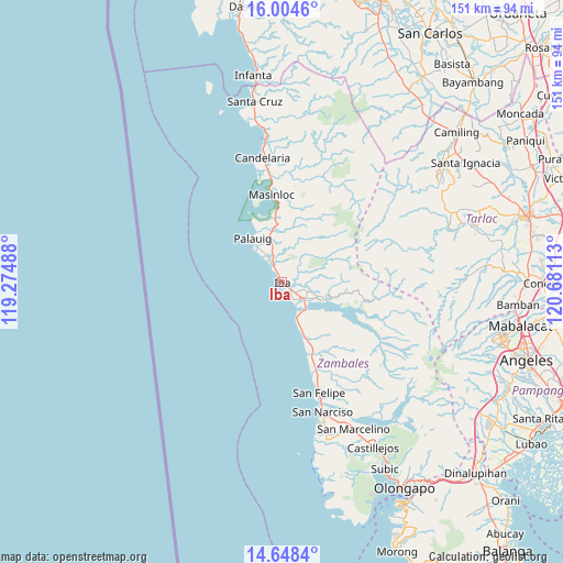
Iba GPS coordinates[2]
15° 19' 39.36" North, 119° 58' 40.8" East
| Map corner | latitude | longitude |
|---|---|---|
| Upper-left | 16.0046°, | 119.27488° |
| Center: | 15.3276°, | 119.978° |
| Lower-right: | 14.6484°, | 120.68113° |
| Map W x H: | 150.8×150.8 km | = 93.7×93.7mi |
| max Lat: | 20.78733° ⇑19.9% North |
| Iba: | 15.3276° |
| min Lat: | ⇓80.1% South 4.65442° |
| min Long | Iba | max Long |
| 117.04868° | 119.978° | 126.58417° |
| W 2.8%⇐ | ⇒97.2% E |
Elevation
Elevation of Iba is 13 m = 43 ft, and this is 74.9 m = 246 ft below average elevation for this country.
| Max E: |
2262 m = 7421 ft | 67.4% |
| Avg. | 87.9 m = 288 ft | |
| Iba | 13 m = 43 ft | |
Min E: |
-2 m = -7 ft | 32.6% |
See also: Philippines elevation on elevation.city.
Geographical zone
Iba is located in North Torrid zone (between Equator and Tropic of Cancer). Distance of this Northern Tropic circle is 901.6 km =560.2 mi to North.| Distance of | km | miles | from Iba |
|---|---|---|---|
| North Pole | 8302.8 | 5159.1 | to North |
| Arctic Circle | 5696.9 | 3539.9 | to North |
| Tropic Cancer | 901.6 | 560.2 | to North |
| Equator | 1704.3 | 1059 | to South |


Nearby cities:
15 places around Iba: (largest is in red/bold)
• Amuñgan
4.7 km =2.9 mi,  333°
333°
• Botolan
6.5 km =4 mi,  130°
130°
• Bulawin
10.2 km =6.3 mi,  346°
346°
• Cabangan
20.7 km =12.9 mi,  155°
155°
• Liozon
9.3 km =5.8 mi, 328°
• Lipay
15.5 km =9.6 mi,  336°
336°
• Maloma
25.5 km =15.8 mi, 158°
• Mambog
5.8 km =3.6 mi,  105°
105°
• Masinloc
23.4 km =14.5 mi, 352°
• Palauig
14.3 km =8.9 mi, 326°
• Panan
13.8 km =8.6 mi, 157°
• Purac
9.4 km =5.8 mi,  153°
153°
• Salaza
14.3 km =8.9 mi, 350°
• San Juan
10.2 km =6.3 mi, 114°
• San Lorenzo
17.7 km =11 mi, 354°
Sources, notices
• [Note1] Compared only with cities in Philippines existing in our database
• [Src1] Map data: © OpenStreetMap contributors (CC-BY-SA)
• [Src2] Other city data from geonames.org with taken over terms of usage.
• [Src3] Geographical zone / Annual Mean Temperature by Robert A. Rohde @ Wikipedia
