Larena geodata
Larena (Central Visayas) is a seat of a third-order administrative division; located in Philippines in Asia/Manila (GMT+8) time zone. In our database, there are 4166 cities with bigger population. Compared to other cities in Philippines, 74.3% of cities are located further ↑North; 63.8% of cities are located further ←West and 61.5% of cities have lower elevation than Larena. Note1


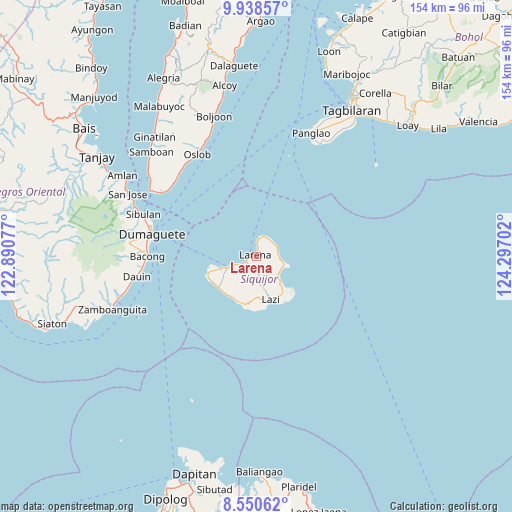
Larena GPS coordinates[2]
9° 14' 43.008" North, 123° 35' 38.004" East
| Map corner | latitude | longitude |
|---|---|---|
| Upper-left | 9.93857°, | 122.89077° |
| Center: | 9.24528°, | 123.59389° |
| Lower-right: | 8.55062°, | 124.29702° |
| Map W x H: | 154.3×154.3 km | = 95.9×95.9mi |
| max Lat: | 20.78733° ⇑74.3% North |
| Larena: | 9.24528° |
| min Lat: | ⇓25.7% South 4.65442° |
| min Long | Larena | max Long |
| 117.04868° | 123.59389° | 126.58417° |
| W 63.8%⇐ | ⇒36.2% E |
Elevation
Elevation of Larena is 36 m = 118 ft, and this is 51.9 m = 170 ft below average elevation for this country.
| Max E: |
2262 m = 7421 ft | 38.5% |
| Avg. | 87.9 m = 288 ft | |
| Larena | 36 m = 118 ft | |
Min E: |
-2 m = -7 ft | 61.5% |
See also: Philippines elevation on elevation.city.
Geographical zone
Larena is located in North Torrid zone (between Equator and Tropic of Cancer). Distance of Equator is 1028 km =638.8 mi to South.| Distance of | km | miles | from Larena |
|---|---|---|---|
| North Pole | 8979.1 | 5579.4 | to North |
| Arctic Circle | 6373.2 | 3960.1 | to North |
| Tropic Cancer | 1577.9 | 980.5 | to North |
| Equator | 1028 | 638.8 | to South |


Nearby cities:
15 places around Larena: (largest is in red/bold)
• Bacong
32.7 km =20.3 mi,  270°
270°
• Banilad
33.2 km =20.6 mi,  276°
276°
• Dauin
36.5 km =22.7 mi,  260°
260°
• Dumaguete
32.7 km =20.3 mi, 282°
• Enrique Villanueva
6.7 km =4.2 mi,  59°
59°
• Lazi
13.7 km =8.5 mi,  160°
160°
• Mainit
33.2 km =20.6 mi,  309°
309°
• Maria
8.4 km =5.2 mi,  128°
128°
• Oslob
35.5 km =22.1 mi,  329°
329°
• San Juan
14.6 km =9.1 mi,  229°
229°
• San Miguel
34 km =21.1 mi, 265°
• Santander Poblacion
34.4 km =21.4 mi, 305°
• Sibulan
36.2 km =22.5 mi,  290°
290°
• Siquijor
9.3 km =5.8 mi,  248°
248°
• Valencia
38.4 km =23.9 mi, 276°
Sources, notices
• [Note1] Compared only with cities in Philippines existing in our database
• [Src1] Map data: © OpenStreetMap contributors (CC-BY-SA)
• [Src2] Other city data from geonames.org with taken over terms of usage.
• [Src3] Geographical zone / Annual Mean Temperature by Robert A. Rohde @ Wikipedia
