Samboan geodata
Samboan (Central Visayas) is a seat of a third-order administrative division; located in Philippines in Asia/Manila (GMT+8) time zone. With population of 3,645 people, there are 1949 cities with bigger population in this country. Compared to other cities in Philippines, 73.1% of cities are located further ↑North; 58.5% of cities are located further ←West and 65.2% of cities have lower elevation than Samboan. Note1


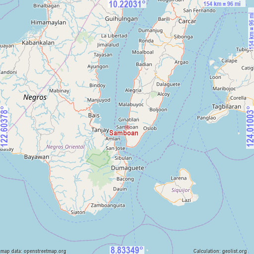
Samboan GPS coordinates[2]
9° 31' 39.36" North, 123° 18' 24.84" East
| Map corner | latitude | longitude |
|---|---|---|
| Upper-left | 10.22031°, | 122.60378° |
| Center: | 9.5276°, | 123.3069° |
| Lower-right: | 8.83349°, | 124.01003° |
| Map W x H: | 154.2×154.2 km | = 95.8×95.8mi |
| max Lat: | 20.78733° ⇑73.1% North |
| Samboan: | 9.5276° |
| min Lat: | ⇓26.9% South 4.65442° |
| min Long | Samboan | max Long |
| 117.04868° | 123.3069° | 126.58417° |
| W 58.5%⇐ | ⇒41.5% E |
Elevation
Elevation of Samboan is 42 m = 138 ft, and this is 45.9 m = 151 ft below average elevation for this country.
| Max E: |
2262 m = 7421 ft | 34.8% |
| Avg. | 87.9 m = 288 ft | |
| Samboan | 42 m = 138 ft | |
Min E: |
-2 m = -7 ft | 65.2% |
See also: Philippines elevation on elevation.city.
Geographical zone
Samboan is located in North Torrid zone (between Equator and Tropic of Cancer). Distance of Equator is 1059.4 km =658.3 mi to South.| Distance of | km | miles | from Samboan |
|---|---|---|---|
| North Pole | 8947.7 | 5559.8 | to North |
| Arctic Circle | 6341.8 | 3940.6 | to North |
| Tropic Cancer | 1546.5 | 961 | to North |
| Equator | 1059.4 | 658.3 | to South |


Nearby cities:
15 places around Samboan: (largest is in red/bold)
• Ginatilan
4.7 km =2.9 mi,  7°
7°
• Jantianon
18 km =11.2 mi,  239°
239°
• Jugno
13.1 km =8.1 mi, 239°
• Mainit
11.9 km =7.4 mi,  151°
151°
• Malabuyoc
14 km =8.7 mi, 8°
• Montaneza
17.6 km =10.9 mi, 7°
• Okiot
16 km =9.9 mi,  285°
285°
• Oslob
13.7 km =8.5 mi,  93°
93°
• Polo
14.8 km =9.2 mi,  249°
249°
• San Jose
14.9 km =9.3 mi,  210°
210°
• Santander Poblacion
11.9 km =7.4 mi,  162°
162°
• Silab
17.2 km =10.7 mi,  234°
234°
• Talangnan
12.2 km =7.6 mi, 14°
• Tandayag
11.7 km =7.3 mi, 226°
• Tanjay
16.4 km =10.2 mi,  265°
265°
Sources, notices
• [Note1] Compared only with cities in Philippines existing in our database
• [Src1] Map data: © OpenStreetMap contributors (CC-BY-SA)
• [Src2] Other city data from geonames.org with taken over terms of usage.
• [Src3] Geographical zone / Annual Mean Temperature by Robert A. Rohde @ Wikipedia
