Sangat geodata
Sangat (Central Visayas) is a populated place; located in Philippines in Asia/Manila (GMT+8) time zone. With population of 4,608 people, there are 1444 cities with bigger population in this country. Compared to other cities in Philippines, 67% of cities are located further ↑North; 65.4% of cities are located further ←West and 67.4% of cities have higher elevation than Sangat. Note1
Administrative division(s):
- Level 1: Central Visayas
- Level 2: Province of Cebu
- Level 3: San Fernando


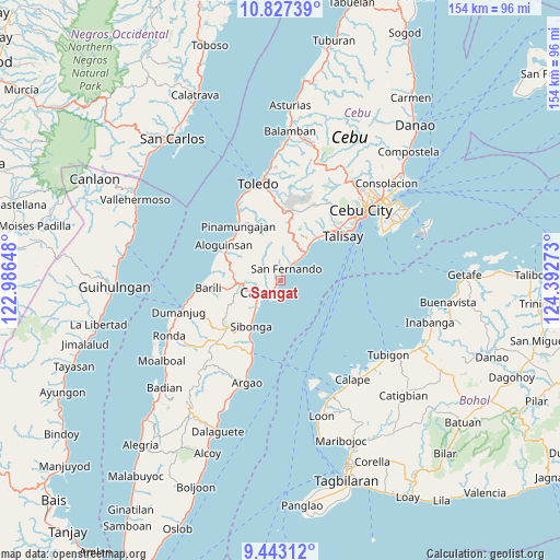
Sangat GPS coordinates[2]
10° 8' 9.6" North, 123° 41' 22.56" East
| Map corner | latitude | longitude |
|---|---|---|
| Upper-left | 10.82739°, | 122.98648° |
| Center: | 10.136°, | 123.6896° |
| Lower-right: | 9.44312°, | 124.39273° |
| Map W x H: | 153.9×153.9 km | = 95.6×95.6mi |
| max Lat: | 20.78733° ⇑67% North |
| Sangat: | 10.136° |
| min Lat: | ⇓33% South 4.65442° |
| min Long | Sangat | max Long |
| 117.04868° | 123.6896° | 126.58417° |
| W 65.4%⇐ | ⇒34.6% E |
Elevation
Elevation of Sangat is 13 m = 43 ft, and this is 74.9 m = 246 ft below average elevation for this country.
| Max E: |
2262 m = 7421 ft | 67.4% |
| Avg. | 87.9 m = 288 ft | |
| Sangat | 13 m = 43 ft | |
Min E: |
-2 m = -7 ft | 32.6% |
See also: Philippines elevation on elevation.city.
Geographical zone
Sangat is located in North Torrid zone (between Equator and Tropic of Cancer). Distance of Equator is 1127 km =700.3 mi to South.| Distance of | km | miles | from Sangat |
|---|---|---|---|
| North Pole | 8880 | 5517.8 | to North |
| Arctic Circle | 6274.2 | 3898.6 | to North |
| Tropic Cancer | 1478.9 | 918.9 | to North |
| Equator | 1127 | 700.3 | to South |


Nearby cities:
15 places around Sangat: (largest is in red/bold)
• Bairan
7.9 km =4.9 mi,  31°
31°
• Balud
1.4 km =0.9 mi, 25°
• Buenavista
10.7 km =6.6 mi,  295°
295°
• Calidñgan
7.3 km =4.5 mi,  236°
236°
• Can-asujan
3.6 km =2.2 mi,  259°
259°
• Carcar
6.3 km =3.9 mi, 238°
• Guadalupe
9.3 km =5.8 mi, 256°
• Langtad
7.4 km =4.6 mi,  41°
41°
• Mantalongon
12 km =7.5 mi, 264°
• Naga
11 km =6.8 mi, 42°
• Ocaña
10.6 km =6.6 mi,  222°
222°
• Pangdan
11.8 km =7.3 mi, 26°
• Perrelos
2.7 km =1.7 mi, 219°
• San Fernando
3.5 km =2.2 mi, 33°
• Valencia
8.4 km =5.2 mi,  270°
270°
Sources, notices
• [Note1] Compared only with cities in Philippines existing in our database
• [Src1] Map data: © OpenStreetMap contributors (CC-BY-SA)
• [Src2] Other city data from geonames.org with taken over terms of usage.
• [Src3] Geographical zone / Annual Mean Temperature by Robert A. Rohde @ Wikipedia
