Ocaña geodata
Ocaña (Central Visayas) is a populated place; located in Philippines in Asia/Manila (GMT+8) time zone. With population of 13,898 people, there are 472 cities with bigger population in this country. Compared to other cities in Philippines, 67.7% of cities are located further ↑North; 64.3% of cities are located further ←West and 56.6% of cities have lower elevation than Ocaña. Note1
Administrative division(s):
- Level 1: Central Visayas
- Level 2: Province of Cebu
- Level 3: City of Carcar


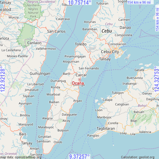
Ocaña GPS coordinates[2]
10° 3' 56.16" North, 123° 37' 27.84" East
| Map corner | latitude | longitude |
|---|---|---|
| Upper-left | 10.75714°, | 122.92128° |
| Center: | 10.0656°, | 123.6244° |
| Lower-right: | 9.37257°, | 124.32753° |
| Map W x H: | 153.9×154 km | = 95.6×95.7mi |
| max Lat: | 20.78733° ⇑67.7% North |
| Ocaña: | 10.0656° |
| min Lat: | ⇓32.3% South 4.65442° |
| min Long | Ocaña | max Long |
| 117.04868° | 123.6244° | 126.58417° |
| W 64.3%⇐ | ⇒35.7% E |
Elevation
Elevation of Ocaña is 29 m = 95 ft, and this is 58.9 m = 193 ft below average elevation for this country.
| Max E: |
2262 m = 7421 ft | 43.4% |
| Avg. | 87.9 m = 288 ft | |
| Ocaña | 29 m = 95 ft | |
Min E: |
-2 m = -7 ft | 56.6% |
See also: Philippines elevation on elevation.city.
Geographical zone
Ocaña is located in North Torrid zone (between Equator and Tropic of Cancer). Distance of Equator is 1119.2 km =695.4 mi to South.| Distance of | km | miles | from Ocaña |
|---|---|---|---|
| North Pole | 8887.9 | 5522.7 | to North |
| Arctic Circle | 6282 | 3903.5 | to North |
| Tropic Cancer | 1486.7 | 923.8 | to North |
| Equator | 1119.2 | 695.4 | to South |


Nearby cities:
15 places around Ocaña: (largest is in red/bold)
• Balud
12 km =7.5 mi,  40°
40°
• Barili
13.6 km =8.5 mi,  293°
293°
• Buenavista
12.7 km =7.9 mi,  348°
348°
• Calidñgan
3.9 km =2.4 mi,  14°
14°
• Can-asujan
8 km =5 mi,  26°
26°
• Carcar
4.8 km =3 mi,  21°
21°
• Guadalupe
6 km =3.7 mi,  341°
341°
• Mantalongon
8.2 km =5.1 mi,  324°
324°
• Perrelos
7.9 km =4.9 mi, 43°
• Sangat
10.6 km =6.6 mi, 42°
• Sibonga
5.5 km =3.4 mi,  188°
188°
• Simala
10.3 km =6.4 mi,  184°
184°
• Tubod
9.6 km =6 mi,  216°
216°
• Tubod-dugoan
13.9 km =8.6 mi,  260°
260°
• Valencia
7.9 km =4.9 mi, 350°
Sources, notices
• [Note1] Compared only with cities in Philippines existing in our database
• [Src1] Map data: © OpenStreetMap contributors (CC-BY-SA)
• [Src2] Other city data from geonames.org with taken over terms of usage.
• [Src3] Geographical zone / Annual Mean Temperature by Robert A. Rohde @ Wikipedia
