San Celestio geodata
San Celestio (Calabarzon) is a populated place; located in Philippines in Asia/Manila (GMT+8) time zone. With population of 2,222 people, there are 3845 cities with bigger population in this country. Compared to other cities in Philippines, 67.9% of cities are located further ↓South; 71% of cities are located further →East and 91.1% of cities have lower elevation than San Celestio. Note1


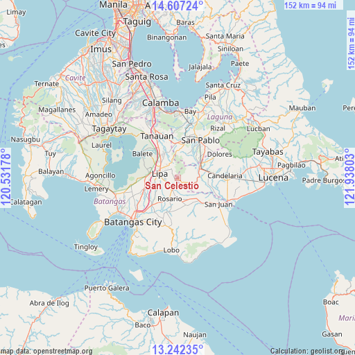
San Celestio GPS coordinates[2]
13° 55' 32.88" North, 121° 14' 5.64" East
| Map corner | latitude | longitude |
|---|---|---|
| Upper-left | 14.60724°, | 120.53178° |
| Center: | 13.9258°, | 121.2349° |
| Lower-right: | 13.24235°, | 121.93803° |
| Map W x H: | 151.8×151.8 km | = 94.3×94.3mi |
| max Lat: | 20.78733° ⇑32.1% North |
| San Celestio: | 13.9258° |
| min Lat: | ⇓67.9% South 4.65442° |
| min Long | San Celestio | max Long |
| 117.04868° | 121.2349° | 126.58417° |
| W 29%⇐ | ⇒71% E |
Elevation
Elevation of San Celestio is 258 m = 846 ft, and this is 170.1 m = 558 ft above average elevation for this country.
| Max E: |
2262 m = 7421 ft | 8.9% |
| San Celestio | 258 m 846 ft | |
| Avg. | 87.9 m = 288 ft | |
Min E: |
-2 m = -7 ft | 91.1% |
See also: Philippines elevation on elevation.city.
Geographical zone
San Celestio is located in North Torrid zone (between Equator and Tropic of Cancer). Distance of this Northern Tropic circle is 1057.5 km =657.1 mi to North.| Distance of | km | miles | from San Celestio |
|---|---|---|---|
| North Pole | 8458.7 | 5256 | to North |
| Arctic Circle | 5852.8 | 3636.8 | to North |
| Tropic Cancer | 1057.5 | 657.1 | to North |
| Equator | 1548.4 | 962.1 | to South |


Nearby cities:
15 places around San Celestio: (largest is in red/bold)
• Ayusan Uno
8.5 km =5.3 mi,  66°
66°
• Banaba
4.2 km =2.6 mi,  219°
219°
• Banaybanay
9.2 km =5.7 mi,  204°
204°
• Bautista
8.9 km =5.5 mi,  31°
31°
• Lipa City
7.9 km =4.9 mi,  282°
282°
• Maugat West
8.8 km =5.5 mi,  144°
144°
• Padre Garcia
5.7 km =3.5 mi, 203°
• Pansol
4.4 km =2.7 mi,  168°
168°
• Quilo-quilo
7.1 km =4.4 mi,  192°
192°
• San Antonio
6.8 km =4.2 mi,  118°
118°
• San Carlos
9.3 km =5.8 mi,  175°
175°
• San Francisco
3.4 km =2.1 mi,  155°
155°
• San Miguel
7 km =4.3 mi,  214°
214°
• Santa Cruz
8.4 km =5.2 mi, 216°
• Talisay
5.9 km =3.7 mi,  327°
327°
Sources, notices
• [Note1] Compared only with cities in Philippines existing in our database
• [Src1] Map data: © OpenStreetMap contributors (CC-BY-SA)
• [Src2] Other city data from geonames.org with taken over terms of usage.
• [Src3] Geographical zone / Annual Mean Temperature by Robert A. Rohde @ Wikipedia
