Bautista geodata
Bautista (Calabarzon) is a populated place; located in Philippines in Asia/Manila (GMT+8) time zone. With population of 2,458 people, there are 3366 cities with bigger population in this country. Compared to other cities in Philippines, 68.9% of cities are located further ↓South; 70.5% of cities are located further →East and 82.7% of cities have lower elevation than Bautista. Note1


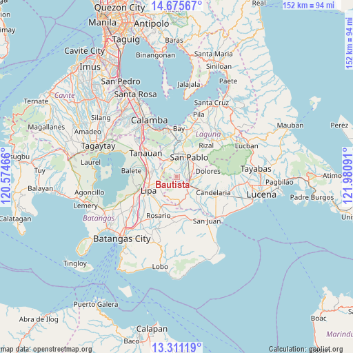
Bautista GPS coordinates[2]
13° 59' 39.984" North, 121° 16' 40.008" East
| Map corner | latitude | longitude |
|---|---|---|
| Upper-left | 14.67567°, | 120.57466° |
| Center: | 13.99444°, | 121.27778° |
| Lower-right: | 13.31119°, | 121.98091° |
| Map W x H: | 151.7×151.7 km | = 94.3×94.3mi |
| max Lat: | 20.78733° ⇑31.1% North |
| Bautista: | 13.99444° |
| min Lat: | ⇓68.9% South 4.65442° |
| min Long | Bautista | max Long |
| 117.04868° | 121.27778° | 126.58417° |
| W 29.5%⇐ | ⇒70.5% E |
Elevation
Elevation of Bautista is 113 m = 371 ft, and this is 25.1 m = 82 ft above average elevation for this country.
| Max E: |
2262 m = 7421 ft | 17.3% |
| Bautista | 113 m 371 ft | |
| Avg. | 87.9 m = 288 ft | |
Min E: |
-2 m = -7 ft | 82.7% |
See also: Philippines elevation on elevation.city.
Geographical zone
Bautista is located in North Torrid zone (between Equator and Tropic of Cancer). Distance of this Northern Tropic circle is 1049.9 km =652.4 mi to North.| Distance of | km | miles | from Bautista |
|---|---|---|---|
| North Pole | 8451 | 5251.2 | to North |
| Arctic Circle | 5845.1 | 3632 | to North |
| Tropic Cancer | 1049.9 | 652.4 | to North |
| Equator | 1556 | 966.9 | to South |


Nearby cities:
15 places around Bautista: (largest is in red/bold)
• Alaminos
8.4 km =5.2 mi,  336°
336°
• Ayusan Uno
5.3 km =3.3 mi,  142°
142°
• Lalig
5.4 km =3.4 mi,  104°
104°
• Lusacan
8.4 km =5.2 mi,  121°
121°
• Quipot
6.2 km =3.9 mi,  134°
134°
• San Andres
9 km =5.6 mi,  313°
313°
• San Celestio
8.9 km =5.5 mi,  211°
211°
• San Gregorio
4.2 km =2.6 mi, 339°
• San Joaquin
8.6 km =5.3 mi, 312°
• San Juan
8.7 km =5.4 mi,  323°
323°
• Santa Cruz
9 km =5.6 mi,  71°
71°
• Santiago
3 km =1.9 mi,  2°
2°
• Santisimo Rosario
3.4 km =2.1 mi,  85°
85°
• Talisay
8.3 km =5.2 mi,  251°
251°
• Tiaong
5.8 km =3.6 mi, 125°
Sources, notices
• [Note1] Compared only with cities in Philippines existing in our database
• [Src1] Map data: © OpenStreetMap contributors (CC-BY-SA)
• [Src2] Other city data from geonames.org with taken over terms of usage.
• [Src3] Geographical zone / Annual Mean Temperature by Robert A. Rohde @ Wikipedia
