Ocampo geodata
Ocampo (Bicol) is a seat of a third-order administrative division; located in Philippines in Asia/Manila (GMT+8) time zone. With population of 2,841 people, there are 2719 cities with bigger population in this country. Compared to other cities in Philippines, 62.7% of cities are located further ↓South; 59.9% of cities are located further ←West and 69.6% of cities have lower elevation than Ocampo. Note1


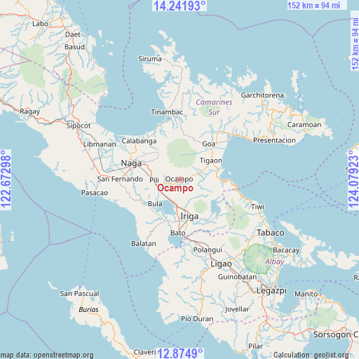
Ocampo GPS coordinates[2]
13° 33' 33.84" North, 123° 22' 33.96" East
| Map corner | latitude | longitude |
|---|---|---|
| Upper-left | 14.24193°, | 122.67298° |
| Center: | 13.5594°, | 123.3761° |
| Lower-right: | 12.8749°, | 124.07923° |
| Map W x H: | 152×152 km | = 94.4×94.4mi |
| max Lat: | 20.78733° ⇑37.3% North |
| Ocampo: | 13.5594° |
| min Lat: | ⇓62.7% South 4.65442° |
| min Long | Ocampo | max Long |
| 117.04868° | 123.3761° | 126.58417° |
| W 59.9%⇐ | ⇒40.1% E |
Elevation
Elevation of Ocampo is 51 m = 167 ft, and this is 36.9 m = 121 ft below average elevation for this country.
| Max E: |
2262 m = 7421 ft | 30.4% |
| Avg. | 87.9 m = 288 ft | |
| Ocampo | 51 m = 167 ft | |
Min E: |
-2 m = -7 ft | 69.6% |
See also: Philippines elevation on elevation.city.
Geographical zone
Ocampo is located in North Torrid zone (between Equator and Tropic of Cancer). Distance of this Northern Tropic circle is 1098.3 km =682.5 mi to North.| Distance of | km | miles | from Ocampo |
|---|---|---|---|
| North Pole | 8499.4 | 5281.3 | to North |
| Arctic Circle | 5893.5 | 3662 | to North |
| Tropic Cancer | 1098.3 | 682.5 | to North |
| Equator | 1507.7 | 936.8 | to South |


Nearby cities:
15 places around Ocampo: (largest is in red/bold)
• Ayugan
6 km =3.7 mi,  256°
256°
• Baao
11.7 km =7.3 mi,  185°
185°
• Bagumbayan
10.6 km =6.6 mi,  171°
171°
• Causip
11.1 km =6.9 mi,  244°
244°
• Curry
9.4 km =5.8 mi,  298°
298°
• Fabrica
11.8 km =7.3 mi,  228°
228°
• Gatbo
2.8 km =1.7 mi,  16°
16°
• Himaao
8.3 km =5.2 mi, 258°
• Pawili
11.1 km =6.9 mi, 244°
• Pinit
4.2 km =2.6 mi,  75°
75°
• Sagrada
8.9 km =5.5 mi,  111°
111°
• Salvacion
10.7 km =6.6 mi,  179°
179°
• Salvacion
11.6 km =7.2 mi,  65°
65°
• San Vicente
11.9 km =7.4 mi, 181°
• Santa Teresita
10.1 km =6.3 mi,  152°
152°
Sources, notices
• [Note1] Compared only with cities in Philippines existing in our database
• [Src1] Map data: © OpenStreetMap contributors (CC-BY-SA)
• [Src2] Other city data from geonames.org with taken over terms of usage.
• [Src3] Geographical zone / Annual Mean Temperature by Robert A. Rohde @ Wikipedia
