Salawagan geodata
Salawagan (Northern Mindanao) is a populated place; located in Philippines in Asia/Manila (GMT+8) time zone. With population of 6,508 people, there are 965 cities with bigger population in this country. Compared to other cities in Philippines, 85.1% of cities are located further ↑North; 89.3% of cities are located further ←West and 92% of cities have lower elevation than Salawagan. Note1
Administrative division(s):
- Level 1: Northern Mindanao
- Level 2: Province of Bukidnon
- Level 3: Quezon


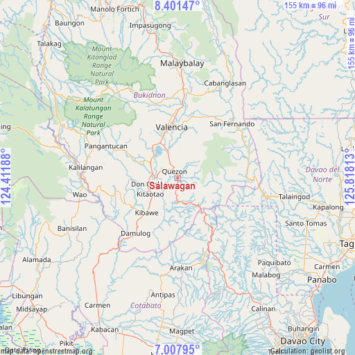
Salawagan GPS coordinates[2]
7° 42' 19.008" North, 125° 6' 54" East
| Map corner | latitude | longitude |
|---|---|---|
| Upper-left | 8.40147°, | 124.41188° |
| Center: | 7.70528°, | 125.115° |
| Lower-right: | 7.00795°, | 125.81813° |
| Map W x H: | 154.9×154.9 km | = 96.3×96.3mi |
| max Lat: | 20.78733° ⇑85.1% North |
| Salawagan: | 7.70528° |
| min Lat: | ⇓14.9% South 4.65442° |
| min Long | Salawagan | max Long |
| 117.04868° | 125.115° | 126.58417° |
| W 89.3%⇐ | ⇒10.7% E |
Elevation
Elevation of Salawagan is 285 m = 935 ft, and this is 197.1 m = 647 ft above average elevation for this country.
| Max E: |
2262 m = 7421 ft | 8% |
| Salawagan | 285 m 935 ft | |
| Avg. | 87.9 m = 288 ft | |
Min E: |
-2 m = -7 ft | 92% |
See also: Philippines elevation on elevation.city.
Geographical zone
Salawagan is located in North Torrid zone (between Equator and Tropic of Cancer). Distance of Equator is 856.7 km =532.3 mi to South.| Distance of | km | miles | from Salawagan |
|---|---|---|---|
| North Pole | 9150.3 | 5685.7 | to North |
| Arctic Circle | 6544.4 | 4066.5 | to North |
| Tropic Cancer | 1749.2 | 1086.9 | to North |
| Equator | 856.7 | 532.3 | to South |


Nearby cities:
15 places around Salawagan: (largest is in red/bold)
• Dalorong
13.4 km =8.3 mi,  171°
171°
• Dancagan
16.2 km =10.1 mi,  228°
228°
• Dologon
17 km =10.6 mi,  332°
332°
• Don Carlos
12.4 km =7.7 mi,  256°
256°
• Kibawe
20.7 km =12.9 mi,  222°
222°
• Kibureau
13 km =8.1 mi,  93°
93°
• Kitaotao
13.8 km =8.6 mi,  238°
238°
• Kitobo
14.6 km =9.1 mi,  184°
184°
• Maramag
13.7 km =8.5 mi,  298°
298°
• Miaray
16.5 km =10.3 mi,  208°
208°
• NIA Valencia
22.5 km =14 mi,  354°
354°
• Natalungan
21.8 km =13.5 mi, 207°
• Quezon
3.3 km =2.1 mi, 327°
• San Jose
6 km =3.7 mi,  305°
305°
• San Vicente
10.7 km =6.6 mi, 235°
Sources, notices
• [Note1] Compared only with cities in Philippines existing in our database
• [Src1] Map data: © OpenStreetMap contributors (CC-BY-SA)
• [Src2] Other city data from geonames.org with taken over terms of usage.
• [Src3] Geographical zone / Annual Mean Temperature by Robert A. Rohde @ Wikipedia
