Ronda geodata
Ronda (Central Visayas) is a seat of a third-order administrative division; located in Philippines in Asia/Manila (GMT+8) time zone. In our database, there are 4166 cities with bigger population. Compared to other cities in Philippines, 68.3% of cities are located further ↑North; 60.6% of cities are located further ←West and 92.7% of cities have higher elevation than Ronda. Note1


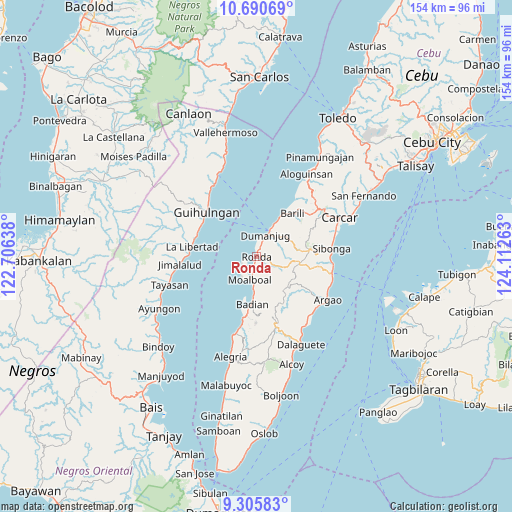
Ronda GPS coordinates[2]
9° 59' 56.4" North, 123° 24' 34.2" East
| Map corner | latitude | longitude |
|---|---|---|
| Upper-left | 10.69069°, | 122.70638° |
| Center: | 9.999°, | 123.4095° |
| Lower-right: | 9.30583°, | 124.11263° |
| Map W x H: | 154×154 km | = 95.7×95.7mi |
| max Lat: | 20.78733° ⇑68.3% North |
| Ronda: | 9.999° |
| min Lat: | ⇓31.7% South 4.65442° |
| min Long | Ronda | max Long |
| 117.04868° | 123.4095° | 126.58417° |
| W 60.6%⇐ | ⇒39.4% E |
Elevation
Elevation of Ronda is 6 m = 20 ft, and this is 81.9 m = 269 ft below average elevation for this country.
| Max E: |
2262 m = 7421 ft | 92.7% |
| Avg. | 87.9 m = 288 ft | |
| Ronda | 6 m = 20 ft | |
Min E: |
-2 m = -7 ft | 7.3% |
See also: Philippines elevation on elevation.city.
Geographical zone
Ronda is located in North Torrid zone (between Equator and Tropic of Cancer). Distance of Equator is 1111.8 km =690.8 mi to South.| Distance of | km | miles | from Ronda |
|---|---|---|---|
| North Pole | 8895.3 | 5527.3 | to North |
| Arctic Circle | 6289.4 | 3908.1 | to North |
| Tropic Cancer | 1494.1 | 928.4 | to North |
| Equator | 1111.8 | 690.8 | to South |


Nearby cities:
15 places around Ronda: (largest is in red/bold)
• Alcantara
2.6 km =1.6 mi,  188°
188°
• Badian
15 km =9.3 mi, 185°
• Basdiot
6.9 km =4.3 mi,  213°
213°
• Bitoon
10.5 km =6.5 mi,  30°
30°
• Bugas
11.2 km =7 mi,  182°
182°
• Cansuje
12.7 km =7.9 mi,  131°
131°
• Cogon
6.5 km =4 mi,  48°
48°
• Dumanjog
7.1 km =4.4 mi,  24°
24°
• Malhiao
12.7 km =7.9 mi, 181°
• Minolos
13.4 km =8.3 mi, 31°
• Moalboal
6.3 km =3.9 mi, 190°
• Saavedra
4.4 km =2.7 mi,  249°
249°
• Santa Cruz
1 km =0.6 mi, 29°
• Tapon
8.1 km =5 mi, 28°
• Tubod-dugoan
11.1 km =6.9 mi,  62°
62°
Sources, notices
• [Note1] Compared only with cities in Philippines existing in our database
• [Src1] Map data: © OpenStreetMap contributors (CC-BY-SA)
• [Src2] Other city data from geonames.org with taken over terms of usage.
• [Src3] Geographical zone / Annual Mean Temperature by Robert A. Rohde @ Wikipedia
