Tubod-dugoan geodata
Tubod-dugoan (Central Visayas) is a populated place; located in Philippines in Asia/Manila (GMT+8) time zone. With population of 3,141 people, there are 2370 cities with bigger population in this country. Compared to other cities in Philippines, 67.9% of cities are located further ↑North; 62.1% of cities are located further ←West and 90.1% of cities have lower elevation than Tubod-dugoan. Note1


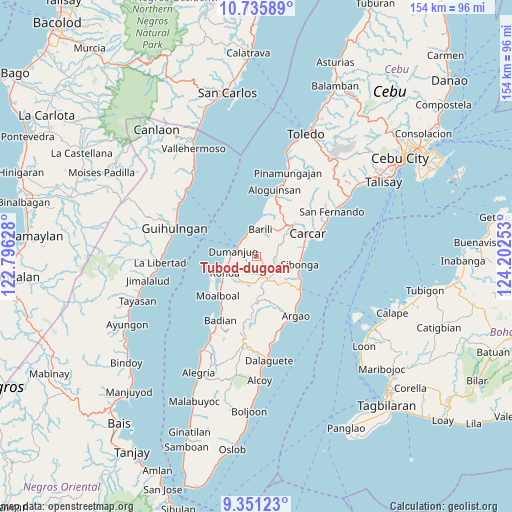
Tubod-dugoan GPS coordinates[2]
10° 2' 39.48" North, 123° 29' 57.84" East
| Map corner | latitude | longitude |
|---|---|---|
| Upper-left | 10.73589°, | 122.79628° |
| Center: | 10.0443°, | 123.4994° |
| Lower-right: | 9.35123°, | 124.20253° |
| Map W x H: | 154×154 km | = 95.7×95.7mi |
| max Lat: | 20.78733° ⇑67.9% North |
| Tubod-dugoan: | 10.0443° |
| min Lat: | ⇓32.1% South 4.65442° |
| min Long | Tubod-dugoan | max Long |
| 117.04868° | 123.4994° | 126.58417° |
| W 62.1%⇐ | ⇒37.9% E |
Elevation
Elevation of Tubod-dugoan is 230 m = 755 ft, and this is 142.1 m = 466 ft above average elevation for this country.
| Max E: |
2262 m = 7421 ft | 9.9% |
| Tubod-dugoan | 230 m 755 ft | |
| Avg. | 87.9 m = 288 ft | |
Min E: |
-2 m = -7 ft | 90.1% |
See also: Philippines elevation on elevation.city.
Geographical zone
Tubod-dugoan is located in North Torrid zone (between Equator and Tropic of Cancer). Distance of Equator is 1116.8 km =693.9 mi to South.| Distance of | km | miles | from Tubod-dugoan |
|---|---|---|---|
| North Pole | 8890.2 | 5524.1 | to North |
| Arctic Circle | 6284.4 | 3904.9 | to North |
| Tropic Cancer | 1489.1 | 925.3 | to North |
| Equator | 1116.8 | 693.9 | to South |


Nearby cities:
15 places around Tubod-dugoan: (largest is in red/bold)
• Alcantara
12.8 km =8 mi,  233°
233°
• Barili
8 km =5 mi,  8°
8°
• Bitoon
6 km =3.7 mi,  312°
312°
• Cansuje
13.5 km =8.4 mi,  181°
181°
• Cogon
5 km =3.1 mi,  260°
260°
• Dumanjog
7.1 km =4.4 mi,  281°
281°
• Guibodangan
8 km =5 mi,  356°
356°
• Japitan
9.3 km =5.8 mi,  2°
2°
• Mantalongon
12.7 km =7.9 mi,  44°
44°
• Minolos
7 km =4.3 mi,  335°
335°
• Ronda
11.1 km =6.9 mi,  242°
242°
• Santa Cruz
10.2 km =6.3 mi,  245°
245°
• Sibonga
13.2 km =8.2 mi,  103°
103°
• Tapon
6.3 km =3.9 mi,  289°
289°
• Tubod
9.6 km =6 mi,  123°
123°
Sources, notices
• [Note1] Compared only with cities in Philippines existing in our database
• [Src1] Map data: © OpenStreetMap contributors (CC-BY-SA)
• [Src2] Other city data from geonames.org with taken over terms of usage.
• [Src3] Geographical zone / Annual Mean Temperature by Robert A. Rohde @ Wikipedia
