Alcantara geodata
Alcantara (Central Visayas) is a seat of a third-order administrative division; located in Philippines in Asia/Manila (GMT+8) time zone. With population of 4,447 people, there are 1521 cities with bigger population in this country. Compared to other cities in Philippines, 68.5% of cities are located further ↑North; 60.4% of cities are located further ←West and 59.2% of cities have higher elevation than Alcantara. Note1


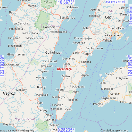
Alcantara GPS coordinates[2]
9° 58' 32.016" North, 123° 24' 21.996" East
| Map corner | latitude | longitude |
|---|---|---|
| Upper-left | 10.6673°, | 122.70299° |
| Center: | 9.97556°, | 123.40611° |
| Lower-right: | 9.28235°, | 124.10924° |
| Map W x H: | 154×154 km | = 95.7×95.7mi |
| max Lat: | 20.78733° ⇑68.5% North |
| Alcantara: | 9.97556° |
| min Lat: | ⇓31.5% South 4.65442° |
| min Long | Alcantara | max Long |
| 117.04868° | 123.40611° | 126.58417° |
| W 60.4%⇐ | ⇒39.6% E |
Elevation
Elevation of Alcantara is 17 m = 56 ft, and this is 70.9 m = 233 ft below average elevation for this country.
| Max E: |
2262 m = 7421 ft | 59.2% |
| Avg. | 87.9 m = 288 ft | |
| Alcantara | 17 m = 56 ft | |
Min E: |
-2 m = -7 ft | 40.8% |
See also: Philippines elevation on elevation.city.
Geographical zone
Alcantara is located in North Torrid zone (between Equator and Tropic of Cancer). Distance of Equator is 1109.2 km =689.2 mi to South.| Distance of | km | miles | from Alcantara |
|---|---|---|---|
| North Pole | 8897.9 | 5528.9 | to North |
| Arctic Circle | 6292 | 3909.7 | to North |
| Tropic Cancer | 1496.7 | 930 | to North |
| Equator | 1109.2 | 689.2 | to South |


Nearby cities:
15 places around Alcantara: (largest is in red/bold)
• Badian
12.4 km =7.7 mi,  184°
184°
• Banhigan
13.1 km =8.1 mi,  188°
188°
• Basdiot
4.6 km =2.9 mi,  227°
227°
• Bitoon
13 km =8.1 mi,  26°
26°
• Bugas
8.6 km =5.3 mi, 180°
• Cansuje
11.5 km =7.1 mi,  120°
120°
• Cogon
8.6 km =5.3 mi,  37°
37°
• Dumanjog
9.6 km =6 mi,  19°
19°
• Malhiao
10.1 km =6.3 mi, 179°
• Moalboal
3.7 km =2.3 mi, 191°
• Ronda
2.6 km =1.6 mi,  8°
8°
• Saavedra
3.9 km =2.4 mi,  285°
285°
• Santa Cruz
3.6 km =2.2 mi, 13°
• Tapon
10.6 km =6.6 mi, 23°
• Tubod-dugoan
12.8 km =8 mi,  53°
53°
Sources, notices
• [Note1] Compared only with cities in Philippines existing in our database
• [Src1] Map data: © OpenStreetMap contributors (CC-BY-SA)
• [Src2] Other city data from geonames.org with taken over terms of usage.
• [Src3] Geographical zone / Annual Mean Temperature by Robert A. Rohde @ Wikipedia
