Panikihan geodata
Panikihan (Calabarzon) is a populated place; located in Philippines in Asia/Manila (GMT+8) time zone. With population of 2,424 people, there are 3422 cities with bigger population in this country. Compared to other cities in Philippines, 67.6% of cities are located further ↓South; 58.7% of cities are located further →East and 65.1% of cities have higher elevation than Panikihan. Note1


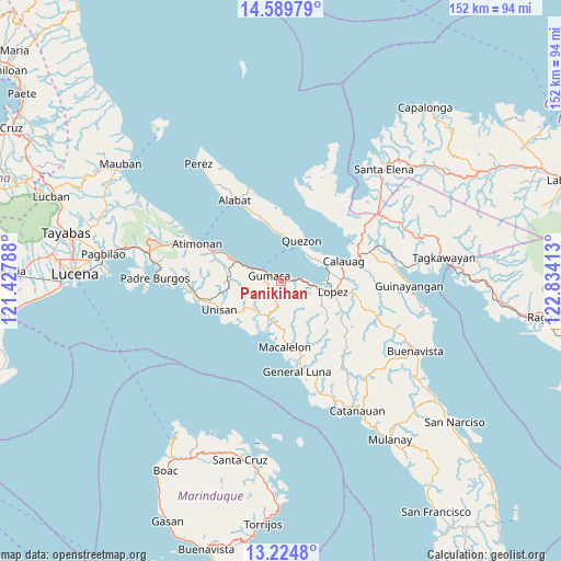
Panikihan GPS coordinates[2]
13° 54' 29.88" North, 122° 7' 51.6" East
| Map corner | latitude | longitude |
|---|---|---|
| Upper-left | 14.58979°, | 121.42788° |
| Center: | 13.9083°, | 122.131° |
| Lower-right: | 13.2248°, | 122.83413° |
| Map W x H: | 151.8×151.8 km | = 94.3×94.3mi |
| max Lat: | 20.78733° ⇑32.4% North |
| Panikihan: | 13.9083° |
| min Lat: | ⇓67.6% South 4.65442° |
| min Long | Panikihan | max Long |
| 117.04868° | 122.131° | 126.58417° |
| W 41.3%⇐ | ⇒58.7% E |
Elevation
Elevation of Panikihan is 14 m = 46 ft, and this is 73.9 m = 242 ft below average elevation for this country.
| Max E: |
2262 m = 7421 ft | 65.1% |
| Avg. | 87.9 m = 288 ft | |
| Panikihan | 14 m = 46 ft | |
Min E: |
-2 m = -7 ft | 34.9% |
See also: Philippines elevation on elevation.city.
Geographical zone
Panikihan is located in North Torrid zone (between Equator and Tropic of Cancer). Distance of this Northern Tropic circle is 1059.5 km =658.3 mi to North.| Distance of | km | miles | from Panikihan |
|---|---|---|---|
| North Pole | 8460.6 | 5257.2 | to North |
| Arctic Circle | 5854.7 | 3637.9 | to North |
| Tropic Cancer | 1059.5 | 658.3 | to North |
| Equator | 1546.5 | 961 | to South |


Nearby cities:
15 places around Panikihan: (largest is in red/bold)
• Calauag
17.8 km =11.1 mi,  72°
72°
• Camohaguin
3.8 km =2.4 mi,  89°
89°
• Gumaca
3.6 km =2.2 mi,  293°
293°
• Hondagua
12.6 km =7.8 mi, 70°
• Lopez
14.2 km =8.8 mi,  100°
100°
• Mabunga
8.5 km =5.3 mi,  233°
233°
• Macalelon
18 km =11.2 mi,  177°
177°
• Pitogo
14.5 km =9 mi,  197°
197°
• Plaridel
13 km =8.1 mi, 293°
• Progreso
4.4 km =2.7 mi,  270°
270°
• Quezon
12.2 km =7.6 mi,  27°
27°
• Rizal
17.1 km =10.6 mi, 74°
• Rosario
16.1 km =10 mi,  107°
107°
• San Vicente
8.1 km =5 mi, 99°
• Unisan
18.4 km =11.4 mi,  246°
246°
Sources, notices
• [Note1] Compared only with cities in Philippines existing in our database
• [Src1] Map data: © OpenStreetMap contributors (CC-BY-SA)
• [Src2] Other city data from geonames.org with taken over terms of usage.
• [Src3] Geographical zone / Annual Mean Temperature by Robert A. Rohde @ Wikipedia
