Calauag geodata
Calauag (Calabarzon) is a populated place; located in Philippines in Asia/Manila (GMT+8) time zone. With population of 20,837 people, there are 361 cities with bigger population in this country. Compared to other cities in Philippines, 68.5% of cities are located further ↓South; 57.3% of cities are located further →East and 85.4% of cities have higher elevation than Calauag. Note1


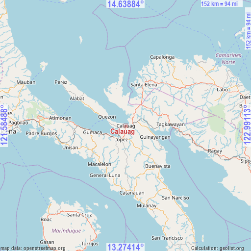
Calauag GPS coordinates[2]
13° 57' 27" North, 122° 17' 16.8" East
| Map corner | latitude | longitude |
|---|---|---|
| Upper-left | 14.63884°, | 121.58488° |
| Center: | 13.9575°, | 122.288° |
| Lower-right: | 13.27414°, | 122.99113° |
| Map W x H: | 151.7×151.7 km | = 94.3×94.3mi |
| max Lat: | 20.78733° ⇑31.5% North |
| Calauag: | 13.9575° |
| min Lat: | ⇓68.5% South 4.65442° |
| min Long | Calauag | max Long |
| 117.04868° | 122.288° | 126.58417° |
| W 42.7%⇐ | ⇒57.3% E |
Elevation
Elevation of Calauag is 8 m = 26 ft, and this is 79.9 m = 262 ft below average elevation for this country.
| Max E: |
2262 m = 7421 ft | 85.4% |
| Avg. | 87.9 m = 288 ft | |
| Calauag | 8 m = 26 ft | |
Min E: |
-2 m = -7 ft | 14.6% |
See also: Philippines elevation on elevation.city.
Geographical zone
Calauag is located in North Torrid zone (between Equator and Tropic of Cancer). Distance of this Northern Tropic circle is 1054 km =654.9 mi to North.| Distance of | km | miles | from Calauag |
|---|---|---|---|
| North Pole | 8455.1 | 5253.8 | to North |
| Arctic Circle | 5849.2 | 3634.5 | to North |
| Tropic Cancer | 1054 | 654.9 | to North |
| Equator | 1551.9 | 964.3 | to South |


Nearby cities:
15 places around Calauag: (largest is in red/bold)
• Basiad
22.7 km =14.1 mi,  13°
13°
• Camohaguin
14.2 km =8.8 mi,  247°
247°
• Guinayangan, Fourth District of Quezon
18.4 km =11.4 mi,  110°
110°
• Gumaca
20.7 km =12.9 mi,  258°
258°
• Hondagua
5.2 km =3.2 mi, 255°
• Kinatakutan
19.4 km =12.1 mi,  90°
90°
• Lopez
8.7 km =5.4 mi,  200°
200°
• Panikihan
17.8 km =11.1 mi, 252°
• Progreso
22 km =13.7 mi, 255°
• Quezon
12.5 km =7.8 mi,  295°
295°
• Rizal
1 km =0.6 mi,  211°
211°
• Rosario
10.6 km =6.6 mi,  188°
188°
• San Francisco
18.5 km =11.5 mi,  180°
180°
• San Vicente
11.2 km =7 mi,  233°
233°
• Santa Cecilia
18.9 km =11.7 mi,  330°
330°
Sources, notices
• [Note1] Compared only with cities in Philippines existing in our database
• [Src1] Map data: © OpenStreetMap contributors (CC-BY-SA)
• [Src2] Other city data from geonames.org with taken over terms of usage.
• [Src3] Geographical zone / Annual Mean Temperature by Robert A. Rohde @ Wikipedia
